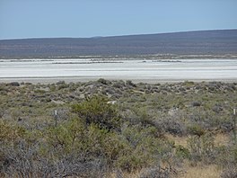
Alkali Lake (Oregon)
| Alkali Lake | |
|---|---|
 Alkali Lake dry lakebed and surrounding desert | |
| Location | Lake County, Oregon |
| Coordinates | 42°58′38″N 120°01′41″W / 42.97722°N 120.02806°W |
| Lake type | seasonal, alkali |
| Basin countries | United States |
| Surface elevation | 4,332 ft (1,320 m) |
Alkali Lake is a geographic sink located in Lake County, Oregon, United States. It lies within the Alkali Subbasin of the Summer Lake Basin watershed in southeastern Oregon.[1] The lake is situated 26 miles east of Christmas Valley, Oregon, northeast of Lake Abert,[2] and directly west of Abert Rim and Highway 395.

Alkali Lake is believed to have reached a prehistoric maximum depth of 270.7 feet (82.5 meters) and covered about 1,448.4 square miles (3,751 square kilometers). Since then, its water level has fluctuated, with a general trend towards drying.[1] Notable features include dissolved alkaline salts averaging 10% of total brine weight in its seasonal waters[2] and a nearby chemical disaster, Alkali Lake Chemical Waste Dump.

Plants
Plants known to occur in the dunes immediately north of the lake include:[3]

- Buckwheat Family
- Goosefoot Family
- Mustard Family
- Evening-primrose family
- Parsley Family
- Phlox Family
- Borage Family
- Sunflower Family
Climate
According to the Köppen Climate Classification system, Alkali Lake has a steppe climate, abbreviated "BSk" on climate maps.

| Climate data for Alkali Lake | |||||||||||||
|---|---|---|---|---|---|---|---|---|---|---|---|---|---|
| Month | Jan | Feb | Mar | Apr | May | Jun | Jul | Aug | Sep | Oct | Nov | Dec | Year |
| Record high °F (°C) | 63 (17) |
72 (22) |
78 (26) |
88 (31) |
97 (36) |
100 (38) |
108 (42) |
105 (41) |
101 (38) |
90 (32) |
75 (24) |
69 (21) |
108 (42) |
| Mean daily maximum °F (°C) | 42.2 (5.7) |
46.1 (7.8) |
51.2 (10.7) |
59.1 (15.1) |
69.1 (20.6) |
77.9 (25.5) |
87.7 (30.9) |
86.4 (30.2) |
78.1 (25.6) |
65.8 (18.8) |
49.9 (9.9) |
41.9 (5.5) |
63 (17) |
| Mean daily minimum °F (°C) | 19.2 (−7.1) |
22.5 (−5.3) |
25.1 (−3.8) |
28.7 (−1.8) |
35 (2) |
42.2 (5.7) |
46.8 (8.2) |
45.5 (7.5) |
37.1 (2.8) |
29.6 (−1.3) |
24.4 (−4.2) |
18.8 (−7.3) |
31.2 (−0.4) |
| Record low °F (°C) | −38 (−39) |
−26 (−32) |
−11 (−24) |
6 (−14) |
4 (−16) |
23 (−5) |
30 (−1) |
26 (−3) |
14 (−10) |
−2 (−19) |
−10 (−23) |
−33 (−36) |
−38 (−39) |
| Average precipitation inches (mm) | 0.61 (15) |
0.54 (14) |
0.77 (20) |
0.84 (21) |
1.22 (31) |
1 (25) |
0.48 (12) |
0.64 (16) |
0.48 (12) |
0.69 (18) |
0.73 (19) |
0.66 (17) |
8.65 (220) |
| Average snowfall inches (cm) | 2.9 (7.4) |
1.8 (4.6) |
1.8 (4.6) |
1.4 (3.6) |
0.5 (1.3) |
0.1 (0.25) |
0 (0) |
0 (0) |
0 (0) |
0.2 (0.51) |
2 (5.1) |
3.8 (9.7) |
14.4 (37) |
| Average precipitation days | 5 | 5 | 7 | 6 | 6 | 5 | 2 | 3 | 3 | 4 | 6 | 6 | 58 |
| Source: [4] | |||||||||||||
See also
References
- ^ a b US Fish & Wildlife Service website
- ^ a b McArthur, p. 10
- ^ "Alkali Lake: 6/24/2003".
- ^ "ALKALI LAKE, OR (350118)". Western Regional Climate Center. Retrieved November 22, 2015.
Works cited
- McArthur, Lewis A. Oregon Geographic Names, Fourth ed. 1974. Edwards Brothers. Ann Arbor, MI
- U.S. Fish and Wildlife Service, Oregon Field Office

See what we do next...
OR
By submitting your email or phone number, you're giving mschf permission to send you email and/or recurring marketing texts. Data rates may apply. Text stop to cancel, help for help.
Success: You're subscribed now !

