

Belaya (Kama)
This article needs additional citations for verification. (February 2014) |
| Belaya | |
|---|---|
 The Belaya in Ufa | |
 Belaya basin | |
.jpg) | |
| Location | |
| Country | Russia |
| Region | Bashkortostan |
| Physical characteristics | |
| Source | Iremel mountains |
| • location | Novokhusainovo, Uchalinsky District |
| • coordinates | 54°33′0″N 59°3′0″E / 54.55000°N 59.05000°E |
| • elevation | 749 m (2,457 ft) |
| Mouth | Kama |
• location | Nizhnekamsk Reservoir |
• coordinates | 55°53′14″N 53°36′14″E / 55.88722°N 53.60389°E |
• elevation | 57 m (187 ft) |
| Length | 1,430 km (890 mi) |
| Basin size | 142,000 km2 (55,000 sq mi) |
| Discharge | |
| • average | 858 m3/s (30,300 cu ft/s) (near Birsk) |
| Basin features | |
| Progression | Kama→ Volga→ Caspian Sea |
 | |
The Belaya (/ˈbɛlaɪə/ BEL-y-ə)[a] is a river in Bashkortostan, Russia. Its source lies in the south-western Ural Mountains.

It is 1,430 kilometres (890 mi) long, and its drainage basin covers 142,000 square kilometres (55,000 sq mi).[1][2]

Settlements along the Belaya include Beloretsk, Sterlitamak, Ufa (at the confluence with the river Ufa), and Birsk. The Belaya flows into the Kama near Neftekamsk.

Tributaries

The largest tributaries of the Belaya are, from source to mouth:[1]

See also
Notes
- ^
- Russian: Белая, romanized: Belaja, IPA: [ˈbʲeɫəjə]; lit. 'white (f.)'
- Bashkir: Ағиҙел, romanized: Ağiźel, IPA: [ɑʁe̝ˈðɪ̞l]
- Tatar: Агыйдел, romanized: Ağıydel, IPA: [ɒʁɯɪˈdel]
References
- ^ a b «Река БЕЛАЯ», Russian State Water Registry
- ^ "Belaya River". Britannica.com. Retrieved 30 May 2016.
Gallery
-
 The middle Belaya valley
 -
 The entrance to the Kapova Cave
 -
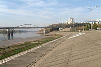 The Belaya River in Ufa


The river Kama | ||
|---|---|---|
Left tributary of the Volga | ||
| Tributaries |  | |
| Reservoirs | ||
| Hydroelectric stations | ||
This Bashkortostan location article is a stub. You can help Wik.ipedia.Pro by expanding it. |
This article related to a river in Russia is a stub. You can help Wik.ipedia.Pro by expanding it. |
See what we do next...
OR
By submitting your email or phone number, you're giving mschf permission to send you email and/or recurring marketing texts. Data rates may apply. Text stop to cancel, help for help.
Success: You're subscribed now !