Chausuyama (Aichi)
| Chausuyama (Mount Chausu) | |
|---|---|
| 茶臼山 | |
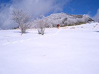
 Mount Chausu from Chausuyama Plateau | |
| Highest point | |
| Elevation | 1,415.23 m (4,643.1 ft) |
| Geography | |
 | |
| Location | Toyone, Aichi / Neba, Nagano, Japan |
| Parent range | Okumikawa |
| Climbing | |
| Easiest route | by car or hiking |

Chausuyama (茶臼山, Mount Chausu) is a mountain located on the border between Aichi and Nagano Prefectures, with its highest point on the Aichi side. With a height of 1,415.2 metres (4,643 ft), it is the tallest peak within Aichi Prefecture. The mountain is within the borders of the Tenryū-Okumikawa Quasi-National Park. During wintertime, the area hosts a popular ski resort.

See also
External links
- Topographical Map Archived 2012-03-26 at the Wayback Machine

35°13′39″N 137°39′20″E / 35.22750°N 137.65556°E

See what we do next...
OR
By submitting your email or phone number, you're giving mschf permission to send you email and/or recurring marketing texts. Data rates may apply. Text stop to cancel, help for help.
Success: You're subscribed now !
