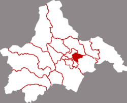
Chenghua, Chengdu
Chenghua
成华区 | |
|---|---|
| District of Chenghua, City of Chengdu | |
 Zhaojue Temple | |
 Location of Chenghua in Chengdu | |
| Coordinates: 30°40′58″N 104°09′13″E / 30.6829°N 104.1536°E[1] | |
| Country | China |
| Province | Sichuan |
| Sub-provincial city | Chengdu |
| Subdivisions | 14 subdistricts |
| District seat | Mengzhuiwan Subdistrict |
| Area | |
| • Total | 110.6 km2 (42.7 sq mi) |
| Population (2010)[2] | |
| • Total | 938,785 |
| • Density | 8,613/km2 (22,310/sq mi) |
| Time zone | UTC+8 (China Standard) |
| Website | www |
Chenghua District (Chinese: 成华区; pinyin: Chénghuá Qū) is an urban district of the City of Chengdu, capital of Sichuan, China.[3]

Chenghua District covers part of the eastern portion of the city. As of 2010[update] it had a population of 938,785 residing in an area of 109 square kilometres (42 sq mi). The district is bordered by Xindu District to the northeast, Longquanyi District to the southeast, Jinjiang District to the south, and Jinniu District to the west.


Administrative divisions
Chenghua District administers 11 subdistricts:[4]

- Mengzhuiwan Subdistrict 猛追湾街道
- Shuanziqiao Subdistrict 双桥子街道
- Fuqinglu Subdistrict 府青路街道
- Erxianqiao Subdistrict 二仙桥街道
- Tiaodenghe Subdistrict 跳蹬河街道
- Shuangshuinian Subdistrict 双水碾街道
- Wannianchang Subdistrict 万年场街道
- Baohe Subdistrict 保和街道
- Qinglong Subdistrict 青龙街道
- Longtan Subdistrict 龙潭街道
- Bailianchi Subdistrict 白莲池街道
Education
The Chengdu University of Technology is also located in Chenghua.

References
- ^ "Chenghua" (Map). Google Maps. Retrieved 2014-07-02.
- ^ 我市2010年第六次全国人口普查数据公报 (in Chinese). Government of Chengdu. 2011-05-13. Archived from the original on 2011-09-30. Retrieved 2011-08-04.
- ^ "走进成华". www.chenghua.gov.cn. Retrieved 2023-10-14.
- ^ 2023年统计用区划代码和城乡划分代码:成华区 (in Simplified Chinese). National Bureau of Statistics of China.
External links
See what we do next...
OR
By submitting your email or phone number, you're giving mschf permission to send you email and/or recurring marketing texts. Data rates may apply. Text stop to cancel, help for help.
Success: You're subscribed now !

