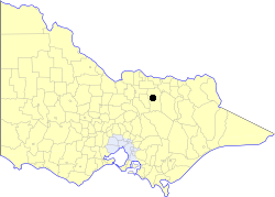
City of Benalla

| City of Benalla Victoria | |
|---|---|
 Location in Victoria | |
| Population | 8,880 (1992)[1] |
| • Density | 500.0/km2 (1,295.0/sq mi) |
| Established | 1948 |
| Area | 17.76 km2 (6.9 sq mi) |
| Council seat | Benalla |
| Region | Hume |
| County | Delatite, Moira |
 | |
The City of Benalla was a local government area about 188 kilometres (117 mi) northeast of Melbourne, the state capital of Victoria, Australia. The city, which was surrounded by the Shire of Benalla, covered an area of 17.76 square kilometres (6.9 sq mi), and existed from 1948 until 1994.

History
The Shire of Benalla was first incorporated as a road district on 4 September 1868, and became a shire on 3 September 1869.

On 1 September 1948, after considerable growth of Benalla as a regional centre, the Central Riding was severed from the shire, to become the Borough of Benalla. Further land was transferred to the borough on 10 April 1956 and 1 February 1964, after which the borough was proclaimed a city by the Governor of Victoria, on 26 May 1965. Two more transfers of land from the shire to the city occurred; on 17 September 1969 and 13 February 1980.[2]

On 18 November 1994, the City of Benalla was abolished, and along with the Shires of Benalla and Mansfield, and the Warrenbayne district of the Shire of Violet Town, was merged into the Shire of Delatite.[3] The Shire of Delatite itself was abolished in 2002, with its former area divided between the Rural City of Benalla and the Shire of Mansfield.

Wards
Benalla was not divided into wards, and the nine councillors represented the entire city.

Population
| Year | Population |
|---|---|
| 1954 | 6,045 |
| 1958 | 7,220* |
| 1961 | 8,234 |
| 1966 | 8,213 |
| 1971 | 8,255 |
| 1976 | 8,300 |
| 1981 | 8,151 |
| 1986 | 8,490 |
| 1991 | 8,334 |
* Estimate in the 1958 Victorian Year Book.

References
- ^ Australian Bureau of Statistics, Victoria Office (1994). Victorian Year Book. p. 52. ISSN 0067-1223.
- ^ Victorian Municipal Directory. Brunswick: Arnall & Jackson. 1992. pp. 304–305, 600–601. Accessed at State Library of Victoria, La Trobe Reading Room.
- ^ Australian Bureau of Statistics (1 August 1995). Victorian local government amalgamations 1994-1995: Changes to the Australian Standard Geographical Classification (PDF). Commonwealth of Australia. p. 5. ISBN 0-642-23117-6. Retrieved 5 January 2008.
External links
36°33′S 145°58′E / 36.550°S 145.967°E

See what we do next...
OR
By submitting your email or phone number, you're giving mschf permission to send you email and/or recurring marketing texts. Data rates may apply. Text stop to cancel, help for help.
Success: You're subscribed now !
