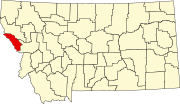
Cyr, Montana

Cyr, Montana | |
|---|---|
| Coordinates: 47°0′27″N 114°34′48″W / 47.00750°N 114.58000°W | |
| Country | United States |
| State | Montana |
| County | Mineral |
| Area | |
| • Total | 1.40 sq mi (3.63 km2) |
| • Land | 1.40 sq mi (3.63 km2) |
| • Water | 0.00 sq mi (0.00 km2) |
| Elevation | 2,963 ft (903 m) |
| Population | |
| • Total | 63 |
| • Density | 44.97/sq mi (17.36/km2) |
| Time zone | UTC-7 (Mountain (MST)) |
| • Summer (DST) | UTC-6 (MDT) |
| ZIP Code | 59820 (Alberton) |
| Area code | 406 |
| FIPS code | 30-18850 |
| GNIS feature ID | 2806648[2] |
Cyr is an unincorporated community and census-designated place (CDP) in Mineral County, Montana, United States. As of the 2020 census, it had a population of 63.[3] It is in the southeastern part of the county, in the valley of the Clark Fork. Interstate 90 crosses the community, with partial access from Exit 70. Alberton is 6 miles (10 km) to the east (upriver), while Superior, the Mineral county seat, is 22 miles (35 km) to the northwest (downriver).

Demographics
| Census | Pop. | Note | %± |
|---|---|---|---|
| 2020 | 63 | — | |
| U.S. Decennial Census[4] | |||
References
- ^ "2023 U.S. Gazetteer Files: Montana". United States Census Bureau. Retrieved May 22, 2024.
- ^ a b U.S. Geological Survey Geographic Names Information System: Cyr, Montana
- ^ a b "P1. Race – Cyr CDP, Montana: 2020 DEC Redistricting Data (PL 94-171)". U.S. Census Bureau. Retrieved May 22, 2024.
- ^ "Census of Population and Housing". Census.gov. Retrieved June 4, 2016.

See what we do next...
OR
By submitting your email or phone number, you're giving mschf permission to send you email and/or recurring marketing texts. Data rates may apply. Text stop to cancel, help for help.
Success: You're subscribed now !


