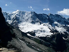
Ebnefluh
| Ebnefluh | |
|---|---|
 The Ebnefluh (left-centre) from the north | |
| Highest point | |
| Elevation | 3,961 m (12,995 ft) |
| Prominence | 201 m (659 ft)[1] |
| Parent peak | Gletscherhorn |
| Coordinates | 46°30′29″N 7°57′11″E / 46.50806°N 7.95306°E |
| Geography | |
| Location | Bern/Valais, Switzerland |
| Parent range | Bernese Alps |
| Climbing | |
| Easiest route | From Hollandia Hut |
The Ebnefluh, also known as the Äbeni Flue and the Ebenefluh, (3,961 m) is a mountain of the Bernese Alps, located on the border between the Swiss cantons of Bern and Valais. It lies towards the eastern end of the Lauterbrunnen Wall.

References
External links

See what we do next...
OR
By submitting your email or phone number, you're giving mschf permission to send you email and/or recurring marketing texts. Data rates may apply. Text stop to cancel, help for help.
Success: You're subscribed now !

