

File:Arrondissement Charleroi Belgium Map.png
No higher resolution available.
Arrondissement_Charleroi_Belgium_Map.png (270 × 203 pixels, file size: 16 KB, MIME type: image/png)

| This is a file from the Wikimedia Commons. Information from its description page there is shown below. Commons is a freely licensed media file repository. You can help. |

|
File:Arrondissement Charleroi Belgium Map.svg is a vector version of this file. It should be used in place of this PNG file when not inferior.
File:Arrondissement Charleroi Belgium Map.png → File:Arrondissement Charleroi Belgium Map.svg
For more information, see Help:SVG. |
 |

Summary
| Description |
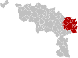
English: Map of Charleroi District in province of Hainaut, Belgium.
Français : Carte indiquant la localisation d'arrondissement de Charleroi dans la Province de Hainaut. |
| Source | Own work |
| Author | LennartBolks, colors by Nicnac25 |
colors changed by me, based on work from w:nl:Gebruiker:LennartBolks/kaartenhoekje also in PD.

Licensing
| This work has been released into the public domain by its author, LennartBolks. This applies worldwide. In some countries this may not be legally possible; if so: |
File history
Click on a date/time to view the file as it appeared at that time.

| Date/Time | Thumbnail | Dimensions | User | Comment | |
|---|---|---|---|---|---|
| current | 14:51, 10 March 2019 | | 270 × 203 (16 KB) | ArnePeirs | Update 2019 |
| 18:37, 29 March 2005 |  | 355 × 278 (5 KB) | Nicnac25~commonswiki | Map of Charleroi District in province of Hainaut, Belgium FR; Carte indiquant la localisation d'arrondissement de Charleroi dans la Province de Hainaut. {{PD}} colors changed by me, based on work from w:nl:Gebruiker:LennartBolks/kaartenhoekje also in |
File usage

Global file usage
The following other wikis use this file:

- Usage on bg.Wik.ipedia.Pro.org
- Usage on br.Wik.ipedia.Pro.org
- Usage on bs.Wik.ipedia.Pro.org
- Usage on cs.Wik.ipedia.Pro.org
- Usage on de.Wik.ipedia.Pro.org
- Usage on es.Wik.ipedia.Pro.org
- Usage on fa.Wik.ipedia.Pro.org
- Usage on frr.Wik.ipedia.Pro.org
- Usage on hr.Wik.ipedia.Pro.org
- Usage on hu.Wik.ipedia.Pro.org
- Usage on it.Wik.ipedia.Pro.org
- Usage on lb.Wik.ipedia.Pro.org
- Usage on lv.Wik.ipedia.Pro.org
- Usage on nl.Wik.ipedia.Pro.org
- Usage on no.Wik.ipedia.Pro.org
- Usage on pt.Wik.ipedia.Pro.org
- Usage on ru.Wik.ipedia.Pro.org
- Usage on simple.Wik.ipedia.Pro.org
- Usage on th.Wik.ipedia.Pro.org
- Usage on tr.Wik.ipedia.Pro.org
- Usage on vec.Wik.ipedia.Pro.org
- Usage on vi.Wik.ipedia.Pro.org
- Usage on vls.Wik.ipedia.Pro.org
- Usage on wa.Wik.ipedia.Pro.org
See what we do next...
OR
By submitting your email or phone number, you're giving mschf permission to send you email and/or recurring marketing texts. Data rates may apply. Text stop to cancel, help for help.
Success: You're subscribed now !