

File:California map showing Del Norte County.png
No higher resolution available.
California_map_showing_Del_Norte_County.png (200 × 231 pixels, file size: 22 KB, MIME type: image/png)

| This is a file from the Wikimedia Commons. Information from its description page there is shown below. Commons is a freely licensed media file repository. You can help. |
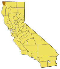
Map of Del Norte county in Claifornia. from en:


|
Permission is granted to copy, distribute and/or modify this document under the terms of the GNU Free Documentation License, Version 1.2 or any later version published by the Free Software Foundation; with no Invariant Sections, no Front-Cover Texts, and no Back-Cover Texts. A copy of the license is included in the section entitled GNU Free Documentation License. |
| This file is licensed under the Creative Commons Attribution-Share Alike 3.0 Unported license. | ||
| ||
| This licensing tag was added to this file as part of the GFDL licensing update. |
File history
Click on a date/time to view the file as it appeared at that time.

| Date/Time | Thumbnail | Dimensions | User | Comment | |
|---|---|---|---|---|---|
| current | 16:57, 1 July 2005 | | 200 × 231 (22 KB) | Pyramide~commonswiki | Map of Del Norte county in Claifornia. from en: {{GFDL}} Category:Maps of counties in California |
File usage
The following 22 pages use this file:

- Adams Station, California
- Bear Mountain (Siskiyou County, California)
- Darlingtonia, California
- Del Norte County Superior Court
- Elk Valley Rancheria
- Fort Ter-Waw
- Four Brothers (mountain range)
- Khoonkhwuttunne, California
- Khwunrghunme, California
- Klamath Glen, California
- Pacific Shores, California
- Peak Eight
- Pelican State Beach
- Point St. George
- Rekwoi, California
- Requa, California
- Sawuara, California
- Scaath, California
- Shegoashkwu, California
- Tatlatunne, California
- Tolowa Dunes State Park
- Template:DelNorteCountyCA-geo-stub
Global file usage
The following other wikis use this file:

- Usage on bg.Wik.ipedia.Pro.org
- Usage on li.Wik.ipedia.Pro.org
- Usage on pam.Wik.ipedia.Pro.org
- Usage on www.wikidata.org
See what we do next...
OR
By submitting your email or phone number, you're giving mschf permission to send you email and/or recurring marketing texts. Data rates may apply. Text stop to cancel, help for help.
Success: You're subscribed now !