

File:Makada (Landsat).jpg
No higher resolution available.
Makada_(Landsat).jpg (316 × 174 pixels, file size: 21 KB, MIME type: image/jpeg)

| This is a file from the Wikimedia Commons. Information from its description page there is shown below. Commons is a freely licensed media file repository. You can help. |
Summary
| Description |
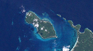
English: This satellite image (Landsat 7) shows Makada Island in the north of Duke of York Islands, Bismarcksea, Papua New Guinea |
| Date | |
| Source | http://oceancolor.gsfc.nasa.gov/cgi/landsat_extract.pl?path=93&row=63&x=423&y=-819&n=0&t=321 |
| Author | NASA |
Licensing
| This file is in the public domain in the United States because it was solely created by NASA. NASA copyright policy states that "NASA material is not protected by copyright unless noted". (See Template:PD-USGov, NASA copyright policy page or JPL Image Use Policy.) | ||
 |
Warnings:
|
File history
Click on a date/time to view the file as it appeared at that time.

| Date/Time | Thumbnail | Dimensions | User | Comment | |
|---|---|---|---|---|---|
| current | 10:56, 11 March 2013 | | 316 × 174 (21 KB) | Wurfzoll | User created page with UploadWizard |
File usage

.jpg)
Global file usage
The following other wikis use this file:

- Usage on ceb.Wik.ipedia.Pro.org
- Usage on www.wikidata.org
See what we do next...
OR
By submitting your email or phone number, you're giving mschf permission to send you email and/or recurring marketing texts. Data rates may apply. Text stop to cancel, help for help.
Success: You're subscribed now !