

File:Map luneburg 1910.jpg

Original file (1,173 × 800 pixels, file size: 621 KB, MIME type: image/jpeg)

| This is a file from the Wikimedia Commons. Information from its description page there is shown below. Commons is a freely licensed media file repository. You can help. |
Summary
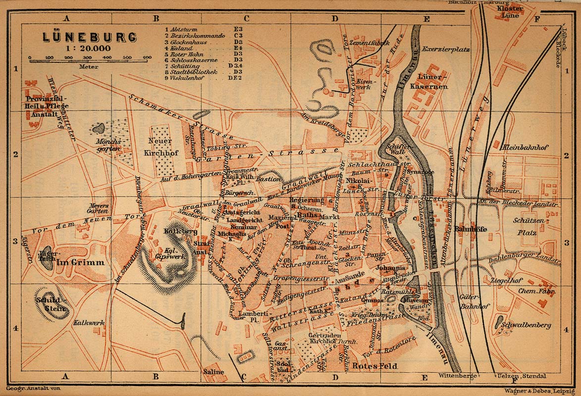
| Description | Town map of Lüneburg, Germany, 1910 |
| Date | |
| Source | http://www.lib.utexas.edu/maps/historical/baedeker_n_germany_1910/luneburg_1910.jpg |
| Author | "Northern Germany as far as the Bavarian and Austrian Frontiers; Handbook for Travellers" by Karl Baedeker. Fifteenth Revised Edition. Leipzig, Karl Baedeker; New York, Charles Scribner's Sons 1910. |
| Permission (Reusing this file) |
"Courtesy of the University of Texas Libraries, The University of Texas at Austin." http://www.lib.utexas.edu/maps/map_sites/hist_sites.html |
Licensing
|
This work is in the public domain in its country of origin and other countries and areas where the copyright term is the author's life plus 70 years or fewer. | |
| This file has been identified as being free of known restrictions under copyright law, including all related and neighboring rights. | |

File history
Click on a date/time to view the file as it appeared at that time.

| Date/Time | Thumbnail | Dimensions | User | Comment | |
|---|---|---|---|---|---|
| current | 09:30, 6 May 2006 | | 1,173 × 800 (621 KB) | 700 MB | tried to remove the stain |
| 02:14, 23 April 2006 |  | 1,173 × 800 (315 KB) | 700 MB | {{Information| |Description=Town map of Lüneburg, Germany |Source=http://www.lib.utexas.edu/maps/historical/baedeker_n_germany_1910/luneburg_1910.jpg |Date=1910 |Author="Northern Germany as far as the Bavarian and Austrian Frontiers; Handbook for Travell |
File usage

Global file usage
The following other wikis use this file:

- Usage on de.Wik.ipedia.Pro.org
- Usage on el.Wik.ipedia.Pro.org
- Usage on et.Wik.ipedia.Pro.org
- Usage on mk.Wik.ipedia.Pro.org
- Usage on nl.Wik.ipedia.Pro.org
- Usage on ru.Wik.ipedia.Pro.org
Metadata
This file contains additional information, probably added from the digital camera or scanner used to create or digitize it.

If the file has been modified from its original state, some details may not fully reflect the modified file.

| _error | 0 |
|---|
See what we do next...
OR
By submitting your email or phone number, you're giving mschf permission to send you email and/or recurring marketing texts. Data rates may apply. Text stop to cancel, help for help.
Success: You're subscribed now !