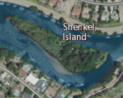
File:NASA Worldwind, USGS imagery map, Shenkel Island, California.png
NASA_Worldwind,_USGS_imagery_map,_Shenkel_Island,_California.png (250 × 200 pixels, file size: 96 KB, MIME type: image/png)

File history
Click on a date/time to view the file as it appeared at that time.

| Date/Time | Thumbnail | Dimensions | User | Comment | |
|---|---|---|---|---|---|
| current | 00:53, 22 February 2021 |  | 250 × 200 (96 KB) | JPxG | {{Information |Description=USGS aerial imagery of w:Shenkel Island in the w:Sacramento-San Joaquin River Delta, with w:Sargent-Barnhart Tract to the north across the w:Calaveras River. |Source=NASA tool at worldwind.earth, USGS Topo Imagery map layer |Date= |Author=USGS, self |Permission={{PD-USGov-USGS}} |other_versions= }} Category:Islands of California Category:Sacramento–San Joaquin River Delta Category:Aerial photographs of river deltas [[Category:Aerial phot... |
File usage
Global file usage
Metadata
See what we do next...
OR
By submitting your email or phone number, you're giving mschf permission to send you email and/or recurring marketing texts. Data rates may apply. Text stop to cancel, help for help.
Success: You're subscribed now !


