

File:Reliefkarte Bern blank.png

Original file (3,905 × 3,531 pixels, file size: 9.43 MB, MIME type: image/png)

| This is a file from the Wikimedia Commons. Information from its description page there is shown below. Commons is a freely licensed media file repository. You can help. |
| Description |
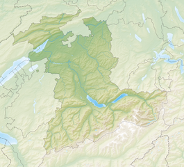
Deutsch: Reliefkarte des Kantons Bern
Topographischer Hintergrund: NASA Shuttle Radar Topography Mission (public domain). SRTM3 v.2. |
||||||||
| Date | |||||||||
| Source | Own work | ||||||||
| Author | Tschubby | ||||||||
| Permission (Reusing this file) |
I, the copyright holder of this work, hereby publish it under the following licenses:
This file is licensed under the Creative Commons Attribution-Share Alike 2.5 Generic, 2.0 Generic and 1.0 Generic license.
You may select the license of your choice. |
||||||||
| Other versions |
 |

File history
Click on a date/time to view the file as it appeared at that time.

| Date/Time | Thumbnail | Dimensions | User | Comment | |
|---|---|---|---|---|---|
| current | 09:08, 17 December 2021 | | 3,905 × 3,531 (9.43 MB) | Tschubby | {{Information |Description= |Source= |Date= |Author= |Permission= |other_versions= }} |
| 15:04, 5 December 2013 |  | 3,909 × 3,535 (13.42 MB) | Tschubby | {{Information |Description= {{de| Reliefkarte des Kantons Bern}} Topographischer Hintergrund: [http://www2.jpl.nasa.gov/srtm NASA Shuttle Radar Topography Mission] (public domain). SRTM3 v.2. |Source={{own}} |Date= 2013-12-05 |Author= [[:de:User:Tschub... |
File usage
More than 100 pages use this file. The following list shows the first 100 pages that use this file only. A full list is available.

- Aarberg
- Aarwangen
- Adelboden
- Aeschi bei Spiez
- Allmendingen bei Bern
- Bargen, Bern
- Belp
- Belprahon
- Bern
- Bern Minster
- Biel/Bienne
- Boltigen
- Bremgarten bei Bern
- Brienz
- Burgdorf, Switzerland
- Busswil bei Büren
- Bévilard
- Büren an der Aare
- Champoz
- Châtelat
- Corcelles, Bern
- Corgémont
- Cormoret
- Cortébert
- Court, Switzerland
- Courtelary
- Crémines
- Diesse
- Eriswil
- Erlenbach im Simmental
- Eschert
- Federal Palace of Switzerland
- Gimmelwald
- Grandval, Switzerland
- Grindelwald
- Grossaffoltern
- Gstaad
- Hasliberg
- Herzogenbuchsee
- Huttwil
- Interlaken
- Iseltwald
- Kandersteg
- Kienersrüti
- La Ferrière, Switzerland
- La Heutte
- La Neuveville
- Lamboing
- Langenthal
- Lauterbrunnen
- Lotzwil
- Loveresse
- Malleray
- Meikirch
- Meiringen
- Monible
- Mont-Tramelan
- Münchenwiler
- Münsingen
- Nods, Switzerland
- Orvin
- Perrefitte
- Plagne, Switzerland
- Pontenet
- Prêles
- Péry
- Rebévelier
- Reconvilier
- Renan, Switzerland
- Ringgenberg
- Roches, Switzerland
- Romont, Bern
- Saanen
- Saicourt
- Saint-Imier
- Saules, Switzerland
- Schelten
- Seehof, Switzerland
- Sonceboz-Sombeval
- Sonvilier
- Sornetan
- Sorvilier
- Souboz
- Spiez
- Tavannes
- Thierachern
- Thun
- Tramelan
- Trub
- Uetendorf
- Vauffelin
- Villeret, Switzerland
- Wald, Bern
- Wangen an der Aare
- Wengen
- Wengi
- Wichtrach
- Zimmerwald
- Zollikofen
- Zweisimmen
View more links to this file.

Global file usage
The following other wikis use this file:

- Usage on af.Wik.ipedia.Pro.org
- Usage on arz.Wik.ipedia.Pro.org
- Usage on da.Wik.ipedia.Pro.org
- Usage on de.Wik.ipedia.Pro.org
- Lauterbrunnental
- Flughafen Bern-Belp
- St. Petersinsel
- Stockhorn
- Niesen (Berg)
- Gantrisch
- Blüemlisalp
- Trümmelbachfälle
- Grimselpass
- Wildhorn
- Gurten (Berg)
- Kernkraftwerk Mühleberg
- Chasseral
- Jolimont
- Unterer Grindelwaldgletscher
- Schloss Rümligen
- Plaine-Morte-Gletscher
- Brünigpass
- Unteraargletscher
- Kanderfirn
- Rudolf von Tavel
- Triftgletscher (Gadmen)
- Oberaargletscher
- Tschingelfirn
- Oberer Grindelwaldgletscher
- Gauligletscher
- Wetterlückengletscher
- Grimselsee
- Engstlensee
- Gelmersee
- Räterichsbodensee
- Lauteraarhorn
- Schreckhorn
- Wohlensee
- Suls-Lobhornhütte
- Oberaarsee
- Morgenberghorn
- Harder Kulm
- Lauberhorn
View more global usage of this file.

Metadata
This file contains additional information, probably added from the digital camera or scanner used to create or digitize it.

If the file has been modified from its original state, some details may not fully reflect the modified file.

| Horizontal resolution | 118.11 dpc |
|---|---|
| Vertical resolution | 118.11 dpc |
See what we do next...
OR
By submitting your email or phone number, you're giving mschf permission to send you email and/or recurring marketing texts. Data rates may apply. Text stop to cancel, help for help.
Success: You're subscribed now !