

File:RuptureAreasNankaiMegathrust.png
Original file (2,103 × 1,439 pixels, file size: 373 KB, MIME type: image/png)

| This is a file from the Wikimedia Commons. Information from its description page there is shown below. Commons is a freely licensed media file repository. You can help. |
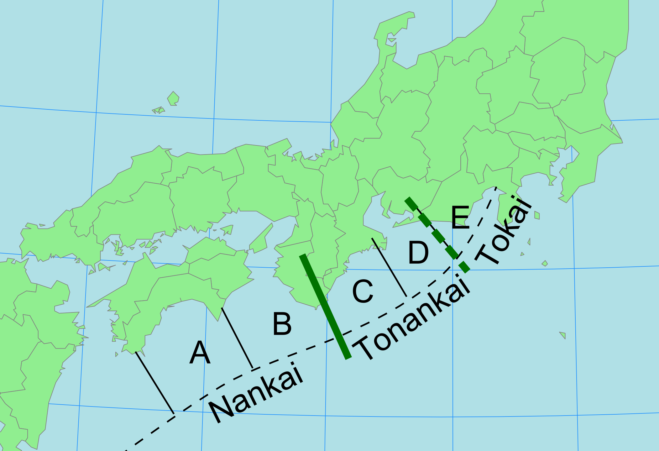
| Description | Cropped version of map chosen only because no prefectures highlighted in critical area. Provided base for map of rupture areas on Nankai Trough megathrust - modified after Ishibashi and Satake 1998 and Hirahara et al. 2005 |
| Date | (UTC) |
| Source | |
| Author |
|
| This is a , which means that it has been digitally altered from its original version. The original can be viewed here: Map of Japan with highlight on 47 Okinawa prefecture.svg:
|
| This file is licensed under the Creative Commons Attribution-Share Alike 3.0 Unported license. | ||
| ||
| This licensing tag was added to this file as part of the GFDL licensing update. |

|
Permission is granted to copy, distribute and/or modify this document under the terms of the GNU Free Documentation License, Version 1.2 or any later version published by the Free Software Foundation; with no Invariant Sections, no Front-Cover Texts, and no Back-Cover Texts. A copy of the license is included in the section entitled GNU Free Documentation License. |
Original upload log
This image is a derivative work of the following images:

- File:Map_of_Japan_with_highlight_on_47_Okinawa_prefecture.svg licensed with Cc-by-sa-3.0-migrated, GFDL
- 2008-04-21T02:22:59Z BetacommandBot 1024x1024 (15591 Bytes) move approved by: [[User:LERK]] This image was moved from [[:Image:Map of Japan with highlight on 47 Okinawa 沖縄県.svg]] {{User:Lincun/都道府県地図情報 |都道府県=沖縄県 |都道府県Latin=Okinawa-ken }}
Uploaded with derivativeFX

File history
Click on a date/time to view the file as it appeared at that time.

| Date/Time | Thumbnail | Dimensions | User | Comment | |
|---|---|---|---|---|---|
| current | 09:38, 28 October 2018 | | 2,103 × 1,439 (373 KB) | Lars A | Removed border. |
| 17:54, 29 November 2009 |  | 2,339 × 1,654 (381 KB) | Mikenorton | {{Information |Description=Cropped version of map chosen chosen because no prefectures highlighted in critical area to provide base for map of rupture areas on Nankai Trough megathrust modified after Ishibashi and Satake 1998 and Hirahara et al. 2005 |Sou |
File usage
The following 6 pages use this file:

Global file usage
The following other wikis use this file:

- Usage on ar.Wik.ipedia.Pro.org
- Usage on es.Wik.ipedia.Pro.org
- Usage on id.Wik.ipedia.Pro.org
- Usage on it.Wik.ipedia.Pro.org
- Usage on ja.Wik.ipedia.Pro.org
- Usage on ko.Wik.ipedia.Pro.org
- Usage on ru.Wik.ipedia.Pro.org
- Usage on vi.Wik.ipedia.Pro.org
- Usage on www.wikidata.org
- Usage on zh.Wik.ipedia.Pro.org
Metadata
This file contains additional information, probably added from the digital camera or scanner used to create or digitize it.

If the file has been modified from its original state, some details may not fully reflect the modified file.

| Horizontal resolution | 78.74 dpc |
|---|---|
| Vertical resolution | 78.74 dpc |
| File change date and time | 09:37, 28 October 2018 |
See what we do next...
OR
By submitting your email or phone number, you're giving mschf permission to send you email and/or recurring marketing texts. Data rates may apply. Text stop to cancel, help for help.
Success: You're subscribed now !