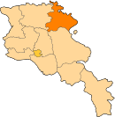
Getahovit
40°53′45″N 45°07′53″E / 40.89583°N 45.13139°E

Getahovit
Գետահովիտ | |
|---|---|
 Mijnashen Church near Getahovit | |
| Coordinates: 40°53′45″N 45°07′53″E / 40.89583°N 45.13139°E | |
| Country | Armenia |
| Province | Tavush |
| Municipality | Ijevan |
| Elevation | 835 m (2,740 ft) |
| Population | |
| • Total | 2,123 |
| Time zone | UTC+4 (AMT) |
| Getahovit at GEOnet Names Server | |
Getahovit (Armenian: Գետահովիտ) is a village in the Ijevan Municipality of the Tavush Province of Armenia.

History
References
External links
See what we do next...
OR
By submitting your email or phone number, you're giving mschf permission to send you email and/or recurring marketing texts. Data rates may apply. Text stop to cancel, help for help.
Success: You're subscribed now !


