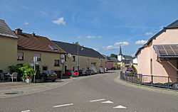
Goesdorf
Goesdorf
Géisdref | |
|---|---|
 | |
 Map of Luxembourg with Goesdorf highlighted in orange, and the canton in dark red | |
| Coordinates: 49°55′00″N 5°58′00″E / 49.9167°N 5.9667°E | |
| Country | |
| Canton | Wiltz |
| Government | |
| • Mayor | Jean-Paul Mathay |
| Area | |
| • Total | 29.41 km2 (11.36 sq mi) |
| • Rank | 27th of 100 |
| Highest elevation | 498 m (1,634 ft) |
| • Rank | 19th of 100 |
| Lowest elevation | 233 m (764 ft) |
| • Rank | 44th of 100 |
| Population (2023) | |
| • Total | 1,664 |
| • Rank | 87th of 100 |
| • Density | 57/km2 (150/sq mi) |
| • Rank | 92nd of 100 |
| Time zone | UTC+1 (CET) |
| • Summer (DST) | UTC+2 (CEST) |
| LAU 2 | LU0000804 |
| Website | goesdorf.lu |
Goesdorf (German pronunciation: [ˈɡøːsˌdɔʁf]; Luxembourgish: Géisdref) is a commune and village in north-western Luxembourg. It is part of the canton of Wiltz.

As of 2024[update], the village of Goesdorf, which lies in the south of the commune, had a population of 308.[1] Other towns within the commune include Buderscheid, Dahl, Nocher, and Nocher-Route.

Population
Graphs are unavailable due to technical issues. There is more info on Phabricator and on MediaWiki.org. |

References
- ^ "Registre national des personnes physiques RNPP : Population par localité". data.public.lu. 2024-01-07.
- ^ "Population par canton et commune". statistiques.public.lu. Retrieved 11 January 2022.
External links
 Media related to Goesdorf at Wikimedia Commons

See what we do next...
OR
By submitting your email or phone number, you're giving mschf permission to send you email and/or recurring marketing texts. Data rates may apply. Text stop to cancel, help for help.
Success: You're subscribed now !

