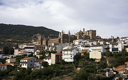
Guadalupe, Cáceres
You can help expand this article with text translated from the corresponding article in Spanish. (June 2020) Click [show] for important translation instructions.
|
Guadalupe | |
|---|---|
 | |
| Coordinates: 39°27′10″N 5°19′39″W / 39.45278°N 5.32750°W | |
| Country | Spain |
| Autonomous community | Extremadura |
| Province | Cáceres |
| Area | |
• Total | 68.19 km2 (26.33 sq mi) |
| Elevation | 640 m (2,100 ft) |
| Population (2018)[1] | |
• Total | 1,887 |
| • Density | 28/km2 (72/sq mi) |
| Time zone | UTC+1 (CET) |
| • Summer (DST) | UTC+2 (CEST) |
 | |
Guadalupe is a municipality of Spain located in the province of Cáceres, Extremadura.[2] It has a total area of 68.19 km2 and, as of 1 January 2021, a registered population of 1,822.[2] The monastery of Santa María de Guadalupe is situated here.

Geography
The Guadalupe River has its origins near the town in the Sierra de las Villuercas. Its highest point, the Pico la Villuerca reaches an altitude of 1603 m.[3]

See also
References
- ^ Municipal Register of Spain 2018. National Statistics Institute.
- ^ a b "Datos del Registro de Entidades Locales". Ministerio de Asuntos Económicos y Transformación Digital. Retrieved 23 May 2022.
- ^ Pico la Villuerca Archived 2013-12-16 at the Wayback Machine
See what we do next...
OR
By submitting your email or phone number, you're giving mschf permission to send you email and/or recurring marketing texts. Data rates may apply. Text stop to cancel, help for help.
Success: You're subscribed now !


