Hamburg Metropolitan Region
Hamburg Metropolitan Region
Metropolregion Hamburg (German) | |
|---|---|
 Hamburg | |
| Anthem: Stadt Hamburg an der Elbe Auen [de] | |
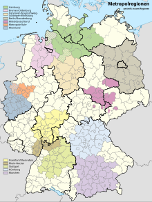
 Location of the Hamburg metropolitan region in Germany | |
| Country | |
| States | |
| Largest Cities | Hamburg, Lübeck |
| Area | |
| • Metro | 26,000 km2 (10,000 sq mi) |
| Population | |
| • Metro | 5,100,000 |
| • Metro density | 192/km2 (500/sq mi) |
| GDP | |
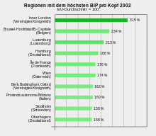
| • Metro | €249.406 billion (2021) |
| Time zone | UTC+1 (CET) |
| Website | http://www.metropolregion.hamburg.de/ |
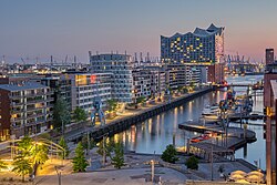
The Hamburg Metropolitan Region (German: Metropolregion Hamburg) is a metropolitan region centred around the city of Hamburg in northern Germany, consisting of eight districts (Landkreise) in the federal state of Lower Saxony, six districts (Kreise) in the state of Schleswig-Holstein and two districts in the state of Mecklenburg-Vorpommern along with the city-state of Hamburg itself. It covers an area of roughly 26,000 square kilometres (10,000 sq mi) and is home to more than 5.1 million inhabitants.

History
On 1 January 2006 the office of the Hamburg Metropolitan Region opened, as agreed in a state treaty of cooperation (Staatsvertrag über Zusammenarbeit) between Hamburg, Lower Saxony and Schleswig-Holstein.[3]

Geography
As of 2005, the Hamburg Metropolitan Region was made up of the city of Hamburg along with numerous rural districts in Lower Saxony and Schleswig-Holstein, altogether comprising 800 cities, towns and municipalities with an overall land area of 19,802 square kilometres (7,646 sq mi).[4] Since then it has expanded to cover the districts of Ludwigslust-Parchim (partially from 2012, entirely from 2017)[5] and Nordwestmecklenburg (from 2012)[6] in the state of Mecklenburg-Vorpommern.

|
States and districts
|
Largest cities and towns
| ||||||||||||||||||||||||||||||||||||||||||||||||||||||||||||||||||||||||||||||||||||||||||||||||||||||||||||||||||||||||||||||||||||||||||||||||||||||||||||||||||||||||||||||||||||||
* Districts and independent (German: kreisfrei) cities.
† Ludwigslust was merged into Ludwigslust-Parchim in 2011; pop. data for 2010


Larger Urban Zones


The Hamburg Larger Urban Zone (LUZ) as defined by Eurostat's Urban Audit covers an area of 7,303 km2 and in 2004 had a population of 3,134,620 inhabitants.[9] The Larger Urban Zone covers only the city of Hamburg and its directly neighbouring districts.[10] The Hamburg LUZ corresponds with the service area of the Hamburger Verkehrsverbund (HVV) transport association with an average population density of at least 150 inhabitants/km2.

| State | District* | Population (2012) |
Area |
Pop. density (2012) |
|---|---|---|---|---|
| – | 1,813,587 | 755 km2 | 2,400/km2 | |
| Harburg | 239,269 | 1,245 km2 | 190/km2 | |
| Stade | 195,606 | 1,266 km2 | 150/km2 | |
| Lauenburg | 187,905 | 1,263 km2 | 150/km2 | |
| Pinneberg | 298,826 | 664 km2 | 450/km2 | |
| Segeberg | 261,988 | 1,334 km2 | 200/km2 | |
| Stormarn | 232,911 | 766 km2 | 300/km2 | |
| Hamburg LUZ[11][12] | 2,903,198 | |||
| Lübeck | 211,713 | 214.13 km2 | 990/km2 | |
| Ostholstein | 197,882 | 1,391 km2 | 140/km2 | |
| Lübeck LUZ[11][12] | 391,373 | |||
| Bremerhaven† | 112,895 | 78,87 km2 | 1,400/km2 | |
| Cuxhaven | 198,115 | 2,073 km2 | 96/km2 | |
| Bremerhaven LUZ[11][12] | 288,635 | |||
* Districts and independent (German: kreisfrei) cities.
† not part of the Hamburg Metropolitan Region

-
Hamburg City Hall (Rathaus), seat of the Hamburg Senate
-
Hamburg's Binnenalster lake
-
Travemünde, seaside resort in Lübeck
-
Historic market place (Marktplatz) in Wismar
See also
References
- ^ "Hamburg" (in German). Archived from the original on 9 April 2016. Retrieved 12 June 2009.
- ^ "Bruttoinlandsprodukt (BIP) in den Metropolregionen* in Deutschland im Jahr 2021" (in German).
- ^ Impressum - metropolregion Hamburg (in German), retrieved 25 March 2009
- ^ Hamburg Metropolitan Area fact sheet (PDF), Statistical office Hamburg and Schleswig-Holstein (Statistisches Amt für Hamburg und Schleswig-Holstein), 2006, archived from the original (PDF) on 18 January 2009, retrieved 25 March 2009
- ^ "Metropolregion Hamburg / Landkreis Ludwigslust-Parchim".
- ^ "Metropolregion Hamburg Landkreis Nordwestmecklenburg".
- ^ Bevölkerungsstand und Bevölkerungsdichte am 31.12.2012, Metropolregion Hamburg, 2013
- ^ Flächennutzung: Siedlungs- und Verkehrsfläche nach Art der tatsächlichen Nutzung am 31.12.2012, Metropolregion Hamburg, 2013
- ^ "Hamburg". Archived from the original on 16 July 2011. Retrieved 15 June 2009.
- ^ http://www.staedtestatistik.de/508.html Archived 2011-10-07 at the Wayback Machine Retrieved 15 June 2009.
- ^ a b c Population by larger urban zone, eurostat, 2014
- ^ a b c Map of metro regions[permanent dead link], eurostat, 2012
External links
- Metropolregion Hamburg - official webpage
53°30′N 10°00′E / 53.5°N 10.0°E

See what we do next...
OR
By submitting your email or phone number, you're giving mschf permission to send you email and/or recurring marketing texts. Data rates may apply. Text stop to cancel, help for help.
Success: You're subscribed now !


