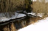
Jäneda (river)
| Jänijõgi Jäneda jõgi | |
|---|---|
 | |
 | |
| Native name | Jänijõgi (Estonian) |
| Location | |
| Country | Estonia |
| Physical characteristics | |
| Source | |
| • location | Käravete |
| • coordinates | 59°11′30″N 25°45′35″E / 59.1917°N 25.7597°E |
| Mouth | |
• location | Jägala River |
• coordinates | 59°16′4″N 25°26′50″E / 59.26778°N 25.44722°E |
| Length | 31.5 km (or 28 km) |
| Basin size | 172 km2 (or 168 km2) |
The Jänijõgi (Estonian: Jänijõgi, Jäneda jõgi) is a river in the Kõrvemaa region of Estonia. It is a right tributary of the Jägala River.[1]

The Jänijõgi originates 5.5 kilometres (3.4 mi) west of Ambla, at the settlement of Käravete in Ambla Parish, 1.2 kilometers northwest of the crossroads, near the southeastern edge of the village of Kukevere. The upper reaches are wooded. The river passes through the village of Jäneda. Records going back to 1591 indicate that the Jäneda Mill on the river was in existence by then.[2]

The river is 31.5 kilometres (19.6 mi)[1] (or 28 kilometres, 17 mi)[2] long, with a watershed basin area of 172 square kilometres (66 sq mi)[1] (or 168 square kilometres, 65 sq mi).[1]

The Tarvasjõgi is a tributary of the Jänijõgi.

References
- ^ a b c d "Jänijõgi". Public Environmental Registry Service. Retrieved September 12, 2016. (in Estonian)
- ^ a b "Jänijõgi". Eestigiid.ee. Retrieved September 12, 2016. (in Estonian)

See what we do next...
OR
By submitting your email or phone number, you're giving mschf permission to send you email and/or recurring marketing texts. Data rates may apply. Text stop to cancel, help for help.
Success: You're subscribed now !


