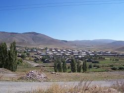
Jajur
40°51′02″N 43°56′53″E / 40.85056°N 43.94806°E

Jajur
Ջաջուռ | |
|---|---|
 Jajur | |
| Coordinates: 40°51′02″N 43°56′53″E / 40.85056°N 43.94806°E | |
| Country | Armenia |
| Province | Shirak |
| Municipality | Akhuryan |
| Population (2001) | |
| • Total | 824 |
| Time zone | UTC+4 |
Jajur (Armenian: Ջաջուռ) is a village in the Akhuryan Municipality of the Shirak Province of Armenia. The village was established in 1828 when a lime extraction facility was established nearby.[1]

Demographics
| Year | Pop. | ±% p.a. | ||
|---|---|---|---|---|
| 1831 | 486 | — | ||
| 1897 | 1,517 | +1.74% | ||
| 1926 | 797 | −2.19% | ||
| 1939 | 1,092 | +2.45% | ||
| 1959 | 815 | −1.45% | ||
| 1970 | 887 | +0.77% | ||
| 1979 | 742 | −1.96% | ||
| 1989 | 563 | −2.72% | ||
| 2001 | 824 | +3.23% | ||
| 2004 | 886 | +2.45% | ||
| ||||
| Source: [2] | ||||
References
- ^ "Հայաստանի եւ հարակից շրջանների տեղանունների բառարան, Թ.Խ. Հակոբյան, Ստ.Տ. Մելիք-Բախշյան, Հ.Խ. Բարսեղյան - Ջաջուռ". www.nayiri.com. Retrieved 2020-01-02.
- ^ Հայաստանի Հանրապետության բնակավայրերի բառարան [Republic of Armenia settlements dictionary] (PDF) (in Armenian). Yerevan: Cadastre Committee of the Republic of Armenia. 2008. Archived from the original (PDF) on 11 March 2018.
- Jajur at GEOnet Names Server
- Report of the results of the 2001 Armenian Census, Statistical Committee of Armenia

See what we do next...
OR
By submitting your email or phone number, you're giving mschf permission to send you email and/or recurring marketing texts. Data rates may apply. Text stop to cancel, help for help.
Success: You're subscribed now !


