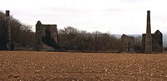
Kelly Bray

This article needs additional citations for verification. (December 2009) |
| Kelly Bray | |
|---|---|
 Old mine buildings near Kelly Bray | |
Location within Cornwall | |
| OS grid reference | SX359715 |
| Civil parish | |
| Shire county | |
| Region | |
| Country | England |
| Sovereign state | United Kingdom |
| Post town | CALLINGTON |
| Postcode district | PL17 |
| Dialling code | 01579 |
| Police | Devon and Cornwall |
| Fire | Cornwall |
| Ambulance | South Western |
| UK Parliament | |

Kelly Bray (Cornish: Kellivre) is a village in east Cornwall, England, United Kingdom. It is situated one mile (1.6 km) north of Callington, immediately west of Kit Hill[1] in a former mining area. Kelly Bray is in the parish of Callington and lies within the St Dominick, Harrowbarrow and Kelly Bray division on Cornwall Council. The population was 3,949 at the 2011 census.[2] Kelly Bray is first recorded ca. 1286 as Kellibregh (Cornish "Kellybregh", meaning "dappled grove").[3]

Kelly Bray was formerly the venue for the Royal Cornwall Show until it was moved to Wadebridge. The village was the location of Callington railway station - terminus of a branch line to Plymouth via Gunnislake. The line was closed beyond Gunnislake in 1966.

Industrial history
Prior to the industrialisation in the 19th century agriculture was the main activity in the land surrounding Kelly Bray.

During the 1820s and 1830s a significant capital investment enabled the development of tin copper and lead mines in the area. In 1843 the mine at Kelly Bray amalgamated with the neighbouring mines of Holmbush and Redmoor to form the Callington Mining Company employing a workforce of over 250 people. The mining activity around Kelly Bray continued until 1946.[4]

In the present day various light industrial businesses are situated in the Florence Road Business Park area of the village.

Cornish wrestling
Cornish wrestling tournaments, for prizes have held at Kelly Bray[5] with a first prize of a silver cup.[6]

References
- ^ Ordnance Survey: Landranger map sheet 201 Plymouth & Launceston ISBN 978-0-319-23146-3
- ^ "ward of Kelly Bray 2011 census". Retrieved 6 February 2015.
- ^ Weatherhill, Craig (2009) A Concise Dictionary of Cornish Place-names. Westport, Mayo: Evertype; p. 42
- ^ "Cornwall Industrial Settlements Initiative | Historic Cornwall" (PDF). 11 December 2020.
- ^ West Briton and Cornwall Advertiser, 2 June 1927.
- ^ Western Morning News, 21 August 1926.
External links
![]() Media related to Kelly Bray at Wikimedia Commons
Media related to Kelly Bray at Wikimedia Commons

See what we do next...
OR
By submitting your email or phone number, you're giving mschf permission to send you email and/or recurring marketing texts. Data rates may apply. Text stop to cancel, help for help.
Success: You're subscribed now !

