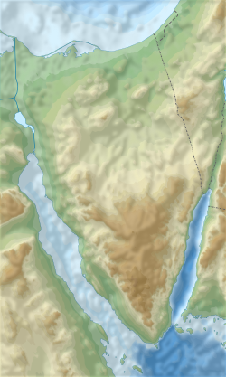
Kuntillet Ajrud
كونتيلة عجرود | |
 | |
| Alternative name | (חורבת תימן) |
|---|---|
| Region | Sinai |
| Coordinates | 30°11′10″N 34°25′41″E / 30.18611°N 34.42806°E |
| History | |
| Material | Stone |
| Periods | Iron Age |
| Cultures | Israelite |
| Site notes | |
| Excavation dates | 1975–76 |
| Archaeologists | Ze’ev Meshel |
Kuntillet ʿAjrud (Arabic: كونتيلة عجرود) or Horvat Teman (Hebrew: חורבת תימן) is a late 9th/early 8th centuries BCE site in the northeast part of the Sinai Peninsula.[1] It is frequently described as a shrine, though this is not certain.[2] The Kuntillet Ajrud inscriptions discovered in the excavations are significant in biblical archaeology.

Kuntillet Ajrud is in the north Sinai; carbon-14 dating indicates occupation from 801–770 BCE, and the eponymous texts may have been written c. 800 BCE.[3] As a perennial water source in this arid region, it constituted an important station on an ancient trade route connecting the Gulf of Aqaba (an inlet of the Red Sea) and the Mediterranean. It was located only 50 kilometers from the major oasis of Kadesh Barnea.[4] Additionally, despite its proximity to the Kingdom of Judah, it has an association with the northern Kingdom of Israel (Samaria): "elements of the material culture such as the pottery, the 'northern' orthography in certain inscriptions, and reference to YHWH of Samaria suggest that Kuntillet ʿAjrud was an Israelite outpost, or at the very least, had a strong Israelite presence".[5]

Investigation
The site then known as "Contellet Garaiyeh", was identified in 1869 by Edward Henry Palmer as "Gypsaria" on the Tabula Peutingeriana: "Our own route, however, from Contellet Garaiyeh to the ruins in Lussan, was, as may be seen from the map, within a mile or so of the distance between Gypsaria and Lysa; and our discovery at the first-mentioned place of the remains of an ancient fort, renders its identity with the third station on the list more than probable."[6][7]


Inscription
The site was excavated in 1975/76 by Tel Aviv University archaeologist Ze’ev Meshel, and the excavation report was published in 2012.[8] The fortress-like main building is divided into two rooms, one large and the other small, both with low benches. Both rooms contained various paintings and inscriptions on the walls and on two large water-jars (pithoi), one found in each room.

The vigorously argued[9] paintings on the pithoi show various animals, stylised trees, and human figures, some of which may represent gods. They appear to have been done over a fairly considerable period and by several different artists, and do not form coherent scenes. The iconography is entirely Syrian/Phoenician and lacks any connection to the Egyptian models commonly found in Iron Age IIB Israel art.[6][10]

See also
References
Citations
- ^ Gnuse 1997, p. 69–70.
- ^ Hadley 2000, p. 108.
- ^ Mastin 2005, p. 326.
- ^ Schniedewind 2017, p. 135.
- ^ Mandell, Alice (1 January 2012). ""I Bless You to YHWH and His Asherah"—Writing and Performativity at Kuntillet ʿAjrud". Maarav. 19 (1–2): 132. doi:10.1086/MAR201219108.
- ^ a b Bonanno, Anthony (March 24, 1986). "Archaeology and Fertility Cult in the Ancient Mediterranean: Papers Presented at the First International Conference on Archaeology of the Ancient Mediterranean, University of Malta, 2-5 September 1985". John Benjamins Publishing – via Google Books.
- ^ Palmer: The desert of the Exodus Volume II, p.422–423
- ^ Meshel et al. 2012.
- ^ Context of Scripture pg II:171 s 2.47 P Kyle McCarter
- ^ Keel & Uehlinger 1998, p. 210ff.
Bibliography
- משל, זאב; מוזיאון ישראל (ירושלים) (1978). כונתילת-עג׳רוד: אתר מקודש מתקופת המלוכה בגבול סיני [Kuntillet Ajrud: A sacred site from the royal period on the Sinai border]. Qaṭalwg / Mwzeyʼwn Yiśraʼel (in Hebrew). מוזיאון ישראל.
- Choi, G. (2016). "The Samarian Syncretic Yahwism and the Religious Center of Kuntillet ʿAjrud". In Ganor, Saar; Kreimerman, Igor; Streit, Katharina; Mumcuoglu, Madeleine (eds.). From Shaʿar Hagolan to Shaaraim: Essays in Honor of Prof. Yosef Garfinkel. Israel Exploration Society. ISBN 978-965-221-111-8.
- Gnuse, Robert Karl (1997). No other gods: emergent monotheism in Israel. Sheffield Academic Press. ISBN 9781850756576.
- Hadley, Judith M. (2000). The Cult of Asherah in Ancient Israel and Judah: Evidence for a Hebrew Goddess. Cambridge University Press. ISBN 9780521662352.
- Keel, Othmar; Uehlinger, Christoph (1998). Gods, goddesses, and images of God in ancient Israel. Fortress Press. ISBN 9780567085917.
- Mastin, B. A. (2005). "Yahweh's Asherah, Inclusive Monotheism and Dating". In Day, John (ed.). In Search of Pre-Exilic Israel. Bloomsbury. ISBN 9780567245540.
- Meshel, Z.; Ben-Ami, D.; Aḥituv, S.; Freud, L.; Sandhaus, D.; Kuper-Blau, T. (2012). Kuntillet ʻAjrud (Ḥorvat Teman): An Iron Age II Religious Site on the Judah-Sinai Border. Israel Exploration Society. ISBN 978-965-221-088-3.
- Schmidt, Brian (2002). "The Iron Age Pithoi Drawings from Horvat Teman or Kuntillet ʿAjrud: Some New Proposals". Journal of Ancient Near Eastern Religions. 2 (1): 91–125. doi:10.1163/156921202762733905. ISSN 1569-2116. S2CID 162385984.
- Schniedewind, William M. (2017). "An Early Iron Age Phase to Kuntillet 'Ajrud?". In Greenspahn, Frederick E.; Rendsburg, Gary A. (eds.). Le-maʿan Ziony: Essays in Honor of Ziony Zevit. Wipf and Stock. ISBN 9781498206914.
- Strawn, Brent A.; LeMon, Joel M. (2018). "Religion in Eighth-Century Judah: The Case of Kuntillet ʿAjrud (and Beyond)". In Farber, Zev I.; Wright, Jacob L. (eds.). Archaeology and History of Eighth-century Judah (PDF). SBL Press. ISBN 9780884143475.
- Wyse-Rhodes, Jackie (2015). "Finding Asherah: The Goddesses in Text and Image". In Hulster, Izaak J. de; LeMon, Joel M. (eds.). Image, Text, Exegesis: Iconographic Interpretation and the Hebrew Bible. Bloomsbury Publishing. ISBN 978-0-567-58828-9.
See what we do next...
OR
By submitting your email or phone number, you're giving mschf permission to send you email and/or recurring marketing texts. Data rates may apply. Text stop to cancel, help for help.
Success: You're subscribed now !

