

List of districts and sub-districts in Denpasar City

-
 Denpasar City Logo
 -
 Map of Denpasar City in Bali
 -
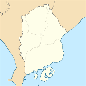 Map of districts in Denpasar
.png)


The following is a list of districts and villages in Denpasar City. Denpasar City comprises 4 districts (kecamatan), subdivided into 16 urban villages (kelurahan) and 27 rural villages (desa). In mid 2022, the population was officially estimated at 726,808 (comprising 366,953 males and 359,855 females) with its area being 125.98 km² and its density 5,769 people/km2.[1]

List of districts and villages in Denpasar City as follows:

| Code | Districts | Urban villages |
Rural villages |
Total villages |
Status | List |
|---|---|---|---|---|---|---|
| 51.71.03 | West Denpasar | 3 | 8 | 11 | Desa | |
| Kelurahan | ||||||
| 51.71.01 | South Denpasar | 6 | 4 | 10 | Desa | |
| Kelurahan | ||||||
| 51.71.02 | East Denpasar | 4 | 7 | 11 | Desa | |
| Kelurahan | ||||||
| 51.71.04 | North Denpasar | 3 | 8 | 11 | Desa | |
| Kelurahan | ||||||
| TOTAL | 16 | 27 | 43 |
See also
References
- ^ Badan Pusat Statistik, Jakarta, 2023, Kota Denpasar Dalam Angka 2023 (Katalog-BPS 1102001.5171)
External links
- Bali Province Official website (in Indonesian)
- Denpasar City Official Website (in Indonesian)
- Official Website Statistical Bureau of Denpasar City (in Indonesian)
See what we do next...
OR
By submitting your email or phone number, you're giving mschf permission to send you email and/or recurring marketing texts. Data rates may apply. Text stop to cancel, help for help.
Success: You're subscribed now !