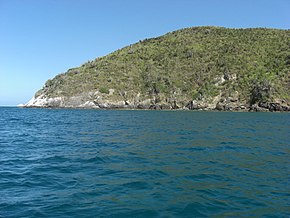
Los Frailes Archipelago
 Los Frailes | |
 | |
| Geography | |
|---|---|
| Location | Caribbean sea |
| Archipelago | Los Frailes |
| Total islands | 10 |
| Major islands | Isla Fraile Grande |
| Area | 1.92 km2 (0.74 sq mi) |
| Administration | |
| Status | Federal Dependency |
| Demographics | |
| Population | 6 (approximately) |
The Islas Los Frailes are an archipelago of rock islets with sparse scrub vegetation belonging to the Federal dependencies of Venezuela, part of Venezuela.[1][2][3][4][5][6]

The flotilla of Spanish explorer Alonso de Ojeda sighted in 1499 the archipelago composed of ten islands:

- Chepere
- Guacaraida
- Isla Fraile Grande
- Nabobo
- Cominoto
- Macarare
- Guairiare
- Guacaraida
- La Balandra
- La Peche
The largest island is called Fraile Grande or Puerto Real and is 2,200 metres (7,218 ft) long and occupies 1.92 km2 (0.74 sq mi). The southern islet has an elevation of 91 m (299 ft). About eight kilometres (5.0 mi) north of Los Failes is Roca del Norte (North Rock), which is 3 m (10 ft) high.

See also
- Federal Dependencies of Venezuela
- List of marine molluscs of Venezuela
- List of Poriferans of Venezuela
References
- ^ Vila, Marco Aurelio. 1967: Aspectos geográficos de las Dependencias Federales. Corporación Venezolana de Fomento. Caracas. 115p.
- ^ Cervigon, Fernando. 1995: Las Dependencias Federales. Academia Nacional de la Historia. Caracas. 193p.
- ^ Hernández Caballero, Serafín (Editor). 1998: Gran Enciclopedia de Venezuela. Editorial Globe, C.A. Caracas. 10 volúmenes. ISBN 980-6427-00-9 ISBN 980-6427-10-6
- ^ Lecuna, Vicente. 1960: Crónica razonada de las guerras de Bolívar. The Colonial Books, New York. 3 volúmenes.
- ^ Jurado Toro, Bernardo. 1980: Bolívar y el mar. Edición del Banco Central de Venezuela. Caracas. 183p.
- ^ Vargas, Francisco Alejandro. 1983: Nuestros héroes navales. Comandancia General de la Armada. Caracas. 2 volúmenes.
External links
- Los Frailes; hfdx.org
11°12′N 63°45′W / 11.200°N 63.750°W


See what we do next...
OR
By submitting your email or phone number, you're giving mschf permission to send you email and/or recurring marketing texts. Data rates may apply. Text stop to cancel, help for help.
Success: You're subscribed now !
