Mashavera
| Mashavera | |
|---|---|
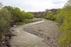
 The Mashavera in Bolnisi | |
 | |
| Native name | მაშავერა (Georgian) |
| Location | |
| Country | Georgia |
| Physical characteristics | |
| Mouth | Khrami |
• coordinates | 41°26′11″N 44°42′54″E / 41.4364°N 44.7150°E |
| Length | 66 km (41 mi) |
| Basin size | 1,390 km2 (540 sq mi) |
| Basin features | |
| Progression | Khrami→ Kura→ Caspian Sea |
The Mashavera (Georgian: მაშავერა) is a river of southern Georgia. It is 66 km (41 mi) long, and has a 1,390 km2 (540 sq mi) drainage basin.[1] It is a right tributary of the Khrami, which in turn is a tributary of the Kura. It flows through the towns of Dmanisi and Bolnisi.

References
- ^ Statistical Yearbook of Georgia: 2020, National Statistics Office of Georgia, Tbilisi, 2020, p. 12.

See what we do next...
OR
By submitting your email or phone number, you're giving mschf permission to send you email and/or recurring marketing texts. Data rates may apply. Text stop to cancel, help for help.
Success: You're subscribed now !
