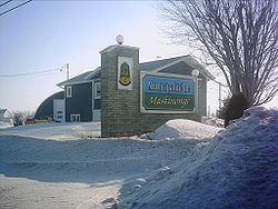
Maskinongé, Quebec

You can help expand this article with text translated from the corresponding article in French. (August 2015) Click [show] for important translation instructions.
|
Maskinongé | |
|---|---|
 | |
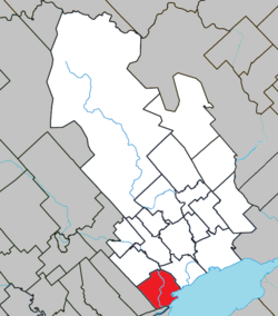
 Location within Maskinongé RCM. | |
| Coordinates: 46°14′N 73°01′W / 46.233°N 73.017°W[1] | |
| Country | |
| Province | |
| Region | Mauricie |
| RCM | Maskinongé |
| Constituted | April 25, 2001 |
| Government | |
| • Mayor | Roger Michaud |
| • Federal riding | Berthier—Maskinongé |
| • Prov. riding | Maskinongé |
| Area | |
• Total | 74.40 km2 (28.73 sq mi) |
| • Land | 74.55 km2 (28.78 sq mi) |
| There is an apparent contradiction between two authoritative sources | |
| Population (2011)[3] | |
• Total | 2,253 |
| • Density | 30.2/km2 (78/sq mi) |
| • Pop 2006-2011 | |
| • Dwellings | 1,093 |
| Time zone | UTC−5 (EST) |
| • Summer (DST) | UTC−4 (EDT) |
| Postal code(s) | |
| Area code | 819 |
| Highways | |
| Website | www |
Maskinongé (French pronunciation: [maskinɔ̃ʒe] ) is a municipality in the Mauricie region of the province of Quebec in Canada.

References
- ^ "Banque de noms de lieux du Québec: Reference number 367126". toponymie.gouv.qc.ca (in French). Commission de toponymie du Québec.
- ^ a b "Répertoire des municipalités: Geographic code 51008". www.mamh.gouv.qc.ca (in French). Ministère des Affaires municipales et de l'Habitation.
- ^ a b "Maskinongé, Quebec (Code 2451008) Census Profile". 2011 census. Government of Canada - Statistics Canada.
External links
 Media related to Maskinongé, Quebec at Wikimedia Commons


See what we do next...
OR
By submitting your email or phone number, you're giving mschf permission to send you email and/or recurring marketing texts. Data rates may apply. Text stop to cancel, help for help.
Success: You're subscribed now !

