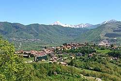
Montereale, Abruzzo
Montereale | |
|---|---|
| Comune di Montereale | |
 | |
| Coordinates: 42°31′30.882″N 13°14′38.1804″E / 42.52524500°N 13.243939000°E | |
| Country | Italy |
| Region | Abruzzo |
| Province | L'Aquila (AQ) |
| Frazioni | Aringo, Busci, Cabbia, Castello, Castel Paganica, Castiglione, Cesaproba, Colle, Ville di Fano - Lonaro, Marana, San Giovanni, Santa Vittoria, Verrico, Casale Bottone, Cavagnano, Colle Cavallari, Cavallari, Colle Calvo, Piedicolle, Colle Verrico, Marignano, Pellescritta, Santa Lucia, San Vito, Cesariano, San Giovanni Paganica, Colle Paganica, Paganica Castello |
| Government | |
| • Mayor | Massimiliano Giorgi |
| Area | |
| • Total | 104.42 km2 (40.32 sq mi) |
| Elevation | 945 m (3,100 ft) |
| Population (30 November 2017)[2] | |
| • Total | 2,486 |
| • Density | 24/km2 (62/sq mi) |
| Demonym | Monterealesi |
| Time zone | UTC+1 (CET) |
| • Summer (DST) | UTC+2 (CEST) |
| Postal code | 67015 |
| Dialing code | 0862 |
| Patron saint | St. Andrew |
| Saint day | September 13 |
| Website | Official website |
Montereale is a comune and town in the province of L'Aquila, in the Abruzzo, region of Italy. It is located in the Gran Sasso e Monti della Laga National Park.

Climate
| Climate data for Montereale, elevation 938 m (3,077 ft), (1951–2000) | |||||||||||||
|---|---|---|---|---|---|---|---|---|---|---|---|---|---|
| Month | Jan | Feb | Mar | Apr | May | Jun | Jul | Aug | Sep | Oct | Nov | Dec | Year |
| Record high °C (°F) | 18.0 (64.4) |
21.0 (69.8) |
22.9 (73.2) |
26.0 (78.8) |
30.1 (86.2) |
32.0 (89.6) |
38.0 (100.4) |
38.0 (100.4) |
33.0 (91.4) |
28.9 (84.0) |
23.0 (73.4) |
19.2 (66.6) |
38.0 (100.4) |
| Mean daily maximum °C (°F) | 6.1 (43.0) |
7.3 (45.1) |
10.2 (50.4) |
12.7 (54.9) |
18.4 (65.1) |
22.6 (72.7) |
26.5 (79.7) |
26.8 (80.2) |
22.1 (71.8) |
16.5 (61.7) |
10.7 (51.3) |
7.0 (44.6) |
15.6 (60.0) |
| Daily mean °C (°F) | 1.7 (35.1) |
2.5 (36.5) |
4.9 (40.8) |
7.5 (45.5) |
12.4 (54.3) |
16.1 (61.0) |
19.1 (66.4) |
19.3 (66.7) |
15.6 (60.1) |
10.9 (51.6) |
6.0 (42.8) |
2.7 (36.9) |
9.9 (49.8) |
| Mean daily minimum °C (°F) | −2.8 (27.0) |
−2.4 (27.7) |
−0.4 (31.3) |
2.3 (36.1) |
6.5 (43.7) |
9.7 (49.5) |
11.8 (53.2) |
11.9 (53.4) |
9.0 (48.2) |
5.2 (41.4) |
1.3 (34.3) |
−1.5 (29.3) |
4.2 (39.6) |
| Record low °C (°F) | −17.4 (0.7) |
−14.0 (6.8) |
−13.0 (8.6) |
−9.0 (15.8) |
−3.6 (25.5) |
0.0 (32.0) |
3.8 (38.8) |
1.0 (33.8) |
−1.8 (28.8) |
−5.0 (23.0) |
−14.0 (6.8) |
−15.0 (5.0) |
−17.4 (0.7) |
| Average precipitation mm (inches) | 71.4 (2.81) |
72.8 (2.87) |
67.7 (2.67) |
77.6 (3.06) |
68.8 (2.71) |
56.6 (2.23) |
36.8 (1.45) |
50.3 (1.98) |
69.0 (2.72) |
84.8 (3.34) |
107.8 (4.24) |
101.9 (4.01) |
865.5 (34.09) |
| Average precipitation days | 9 | 9 | 9 | 11 | 9 | 7 | 5 | 6 | 7 | 9 | 10 | 10 | 101 |
| Source: Regione Abruzzo[3] | |||||||||||||
See also
References
- ^ "Superficie di Comuni Province e Regioni italiane al 9 ottobre 2011". Italian National Institute of Statistics. Retrieved 16 March 2019.
- ^ "Popolazione Residente al 1° Gennaio 2018". Italian National Institute of Statistics. Retrieved 16 March 2019.
- ^ "VALORI MEDI CLIMATICI DAL 1951 AL 2000 NELLA REGIONE ABRUZZO" (PDF). Regione Abruzzo. Archived from the original (PDF) on 30 June 2024. Retrieved 30 June 2024.
See what we do next...
OR
By submitting your email or phone number, you're giving mschf permission to send you email and/or recurring marketing texts. Data rates may apply. Text stop to cancel, help for help.
Success: You're subscribed now !


