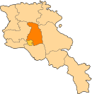
Mrgashen
40°17′06″N 44°32′32″E / 40.28500°N 44.54222°E

Mrgashen Մրգաշեն | |
|---|---|
| Coordinates: 40°17′06″N 44°32′32″E / 40.28500°N 44.54222°E | |
| Country | Armenia |
| Marz (Province) | Kotayk |
| Founded | 1950[2]/March 1960 |
| Area | |
| • Total | 10.97 km2 (4.24 sq mi) |
| Elevation | 1,280 m (4,200 ft) |
| Population (2011) | |
| • Total | 1,933[1] |
| Time zone | UTC+4 ( ) |
Mrgashen (Armenian: Մրգաշեն; until 1964, "the village attached to Sovkhoz No. 36") is a village in the Kotayk Province of Armenia. It is located along the left bank of the Arzni-Shamiram aqueduct. Mrgashen was officially founded in March 1960 around the state-owned collective farm, or Sovkhoz No. 6. The local economy is highly dependent on agriculture, based primarily on orchard cultivation and pig or cattle breeding. The community currently has a school, kindergarten, house of culture (seating for 300), medical station (with six employees), and a library. Sixty percent of households receive natural gas, and drinking water for the village comes from the Arzakan-Yerevan network, while water for irrigation comes from the Arzni-Shamiram aqueduct.[2][3]

See also
References
- ^ "Kotayk (Armenia): Towns and Villages in Municipalities". www.citypopulation.de. Retrieved 2024-11-07.
- ^ a b Kiesling, Brady; Kojian, Raffi (2005). Rediscovering Armenia: Guide (2nd ed.). Yerevan: Matit Graphic Design Studio. p. 100. ISBN 99941-0-121-8.
- ^ "Mrgashen(Kotayk)". CAA: Union of Communities of Armenia. Retrieved June 2, 2015.
See what we do next...
OR
By submitting your email or phone number, you're giving mschf permission to send you email and/or recurring marketing texts. Data rates may apply. Text stop to cancel, help for help.
Success: You're subscribed now !


