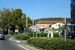
Municipality of Hrpelje-Kozina
Municipality of Hrpelje-Kozina
Občina Hrpelje - Kozina | |
|---|---|
 Hrpelje | |
 Location of the Municipality of Hrpelje-Kozina in Slovenia | |
| Coordinates: 45°35′N 13°59′E / 45.583°N 13.983°E | |
| Country | |
| Government | |
| • Mayor | Saša Likavec Svetelšek |
| Area | |
• Total | 192.2 km2 (74.2 sq mi) |
| Population (2002)[1] | |
• Total | 4,038 |
| • Density | 21/km2 (54/sq mi) |
| Time zone | UTC+01 (CET) |
| • Summer (DST) | UTC+02 (CEST) |
| Website | www |
The Municipality of Hrpelje-Kozina (pronounced [xəɾˈpeːljɛ kɔˈziːna]; Slovene: Občina Hrpelje - Kozina) is a municipality in the Littoral region of Slovenia.[2] Its seat is the village of Hrpelje.

A major border crossing to Italy is located in the municipality at the village of Krvavi Potok. It connects to Pesek in the Municipality of San Dorligo della Valle (Dolina) near Trieste on the Italian side. It borders Italy and Croatia.

Settlements
In addition to the municipal seat of Hrpelje, the municipality also includes the following settlements:

- Artviže
- Bač pri Materiji
- Beka
- Brezovica
- Brezovo Brdo
- Golac
- Gradišče pri Materiji
- Gradišica
- Hotična
- Javorje
- Klanec pri Kozini
- Kovčice
- Kozina
- Krvavi Potok
- Markovščina
- Materija
- Mihele
- Mrše
- Nasirec
- Obrov
- Ocizla
- Odolina
- Orehek pri Materiji
- Ostrovica
- Petrinje
- Poljane pri Podgradu
- Povžane
- Prešnica
- Ritomeče
- Rodik
- Rožice
- Skadanščina
- Slivje
- Slope
- Tatre
- Tublje pri Hrpeljah
- Velike Loče
- Vrhpolje
References
External links
 Media related to Municipality of Hrpelje-Kozina at Wikimedia Commons
- Municipality of Hrpelje-Kozina on Geopedia


See what we do next...
OR
By submitting your email or phone number, you're giving mschf permission to send you email and/or recurring marketing texts. Data rates may apply. Text stop to cancel, help for help.
Success: You're subscribed now !


