Ogallah, Kansas

Ogallah, Kansas | |
|---|---|
 | |
| Coordinates: 38°59′29″N 99°43′56″W / 38.99139°N 99.73222°W[1] | |
| Country | United States |
| State | Kansas |
| County | Trego |
| Founded | 1870s |
| Named for | Oglala Lakota tribe |
| Elevation | 2,336 ft (712 m) |
| Population | |
| • Total | 28 |
| Time zone | UTC-6 (CST) |
| • Summer (DST) | UTC-5 (CDT) |
| ZIP code | 67656 |
| Area code | 785 |
| FIPS code | 20-52250 [1] |
| GNIS ID | 485296 [1] |
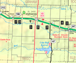
Ogallah is a census-designated place (CDP) in Trego County, Kansas, United States.[1] As of the 2020 census, the population was 28.[2] It is located approximately 7 miles east of WaKeeney.

History
Ogallah was named for the Oglala Lakota tribe.[3]

The post office was established January 27, 1879.[4]

Geography
Climate
The climate in this area is characterized by hot, humid summers and generally mild to cool winters. According to the Köppen Climate Classification system, Ogallah has a humid subtropical climate, abbreviated "Cfa" on climate maps.[5]

Demographics
| Census | Pop. | Note | %± |
|---|---|---|---|
| 2020 | 28 | — | |
| U.S. Decennial Census | |||
See also
References
- ^ a b c d e "Ogallah, Kansas", Geographic Names Information System, United States Geological Survey, United States Department of the Interior
- ^ a b "Profile of Ogallah, Kansas (CDP) in 2020". United States Census Bureau. Archived from the original on November 22, 2021. Retrieved November 22, 2021.
- ^ Heim, Michael (2007). Exploring Kansas Highways. p. 30. ISBN 9780974435886.
- ^ "Kansas Post Offices, 1828-1961". Kansas Historical Society. Archived from the original on October 9, 2013. Retrieved June 27, 2014.
- ^ Climate Summary for Ogallah, Kansas
Further reading
External links

See what we do next...
OR
By submitting your email or phone number, you're giving mschf permission to send you email and/or recurring marketing texts. Data rates may apply. Text stop to cancel, help for help.
Success: You're subscribed now !


