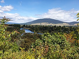
Pihanga

| Pihanga | |
|---|---|
 | |
| Highest point | |
| Elevation | 1,326 m (4,350 ft) |
| Coordinates | 39°02′29″S 175°46′07″E / 39.04139°S 175.76861°E |
| Geography | |
 Map of volcanic features near Pihanga (red marker). Surface volcanic deposits are shaded. To its immediate south west is Lake Rotoaira and beyond is Mount Tongariro with its recent vents active in the last 15,000 years shaded orange-yellow, with craters in yellow outline. Lakes in vents are outlined in blue. Rhyolitic ignimbrite surface deposits are from eruptions of the Taupō Volcano.
Clicking on the map enlarges it, and enables panning and mouseover of volcano name/wikilink and ages before present. Key for the volcanics that are shown with panning is: basalt (shades of brown/orange), monogenetic basalts, undifferentiated basalts of the Tangihua Complex in Northland Allochthon, arc basalts, arc ring basalts, andesite (shades of red), basaltic andesite, and plutonic. White shading is selected caldera features. | |
| Geology | |
| Mountain type | Stratovolcano |
| Last eruption | at least 20,000 years ago[1] |
Pihanga is a 1,326 metres (4,350 ft)[2] andesitic volcanic peak in the North Island Volcanic Plateau, located to the north of Mount Tongariro, between Tongariro and Lake Taupō. The nearest town to Pihanga is Tūrangi.

Lake Rotoaira lies to the south-west of Pihanga, and the smaller Lake Rotopounamu is situated on the south-western flank of the volcano, near Te Ponanga Saddle. Across the saddle to the west is the volcanic peak of Tihia.

Pihanga and Lake Rotopounamu are part of the 5,129ha Pihanga Scenic Reserve, which in 1975 was added to the Tongariro National Park.

Pihanga appears to have a large crater, but this is in fact the result of erosion, and the "crater" quickly narrows into a steep gorge.

Geology
Eruptions from Pihanga last occurred more than 20,000 years ago.[1] An age of 123 ± 10 ka has been challenged and potentially redating suggests first formation greater than 180,000 years ago.[3]: 13, 284 The more recent eruptions are consistent with the north-north-east to south-south-west alignment of the present southern Taupō Volcanic Zone rifting. Just to the east is the Poutu Fault Zone.

Biology
Its slopes are covered in native bush and currently part of a major nature conservation project.[4]

Māori mythology
In Māori mythology, Pīhanga was the female mountain whom Taranaki and Tongariro fought over, at a time when Taranaki was also located among the central North Island mountains. Tongariro's victory resulted in Taranaki's banishment to the west coast, with his movement creating features such as the Whanganui and Pātea Rivers, and the Ngaere swamp.

The Keepers of the Wai
In Māori custom, the Pihanga Maunga became the responsibility of the Matapuna people (a mix of Tuwharetoa, Tama Kopiri/Upper Whanganui whanau/Tu Hope - Descendants of Te Rere Ao, the First of Tuwharetoa) of the Tuwharetoa people, who have traditionally been the keepers of the wai (Keepers of the Water) and Maunga Kaitiaki (Protectors of the Mountain). The Pihanga mountain was an important water resource for the whole of the Tuwharetoa, Tainui, Whanganui and some parts of the East Coast rohe, are all catchments of this water source.

Some members of the chieftain line of the Matapuna people, who held mana, were given the honor of being buried on the mountain. One such chief, Pakau, interred his son, who was killed in battle, in one of the burial caves. Pakau was known to have mourned for many months over the death of his son.[5]

See also
References
- ^ a b Topping, Wayne William (1974). "Some Aspects of Quaternary History of Tongariro Volcanic Centre".
- ^ Index Mundi: New Zealand: Mountains: Pihanga to Poarangitautahi
- ^ Pure, Leo (2020). The volcanic and magmatic evolution of Tongariro volcano, New Zealand (PDF) (Thesis). Te Herenga Waka-Victoria University of Wellington. Retrieved 6 December 2023.
- ^ "Rotopounamu Pihanga Restoration". Retrieved 2022-08-07.
- ^ Kahui Maunga Vol. 1 Page 125, Page 126 A history of the Tuwharetoa People
External links
- United Nations Environment Programme: Parks and Protected Areas: World Heritage Sites: Tongariro National Park
- Best, Elsdon. The Maori - Volume I, V Myth and Folk Lore. p205.
- Peter Thomson: Walks, GPS Tracks and many photographs: New Zealand: Rotopounamu
See what we do next...
OR
By submitting your email or phone number, you're giving mschf permission to send you email and/or recurring marketing texts. Data rates may apply. Text stop to cancel, help for help.
Success: You're subscribed now !

