

Piyain River
| Piyain River | |
|---|---|
.jpg) | |
| Location | |
| Countries | India, Bangladesh |
| District | Sylhet |
| Physical characteristics | |
| Source | |
| • location | Umgat river of Assam |
| Mouth | |
• location | Surma River |
| Length | 145 kilometres (90 mi) |
Piyain River a trans-boundary river of India and Bangladesh.[1] It is a tributary of the Surma river, which is originates from the Umngot of Meghalaya. The river enters Bangladesh through Sylhet district.

The origin and flow
The length of the river is 145 km.[2] Piyain river has emerged from the river om or Umagat river or Assam.[3]

Gallery
-

-

-

-
 Piyain River at Zero Point Jaflong
 -
 Piyain River at Chhatak Upazila
 -
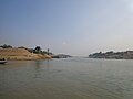
 Piyain River. The picture was taken on the way to Bisnakandi
.JPG)
.jpg)
.jpg)
.jpg)


References
- ^ The story of a River of Jaflong in Bangladesh
- ^ Masud Hasan Chowdhury (2012), "Piyain River", in Sirajul Islam and Ahmed A. Jamal (ed.), Banglapedia: National Encyclopedia of Bangladesh (Second ed.), Asiatic Society of Bangladesh
- ^ Tourist Spot - Piyain River
External links
24°46′N 91°06′E / 24.767°N 91.100°E

See what we do next...
OR
By submitting your email or phone number, you're giving mschf permission to send you email and/or recurring marketing texts. Data rates may apply. Text stop to cancel, help for help.
Success: You're subscribed now !