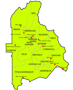
Rembau District
Rembau District | |
|---|---|
| Daerah Rembau | |
| Other transcription(s) | |
| • Jawi | رمباو |
| • Chinese | 林茂县 |
| • Tamil | ரெம்பாவ் |
 Location of Rembau District in Negeri Sembilan | |
 | |
Location of Rembau District in Malaysia | |
| Coordinates: 2°35′N 102°05′E / 2.583°N 102.083°E | |
| Country | |
| State | |
| Seat | Rembau |
| Local area government(s) | Rembau District Council |
| Government | |
| • District officer | Amino Agos Suyub [1] |
| Area | |
• Total | 415.12 km2 (160.28 sq mi) |
| Population (2010)[3] | |
• Total | 41,325 |
| • Density | 100/km2 (260/sq mi) |
| Time zone | UTC+8 (MST) |
| • Summer (DST) | UTC+8 (Not observed) |
| Postcode | 71xxx |
| Calling code | +6-06 |
| Vehicle registration plates | N |
Rembau | |
|---|---|
| Luak Rembau لواق رمباو | |
 Luak of Rembau relative to other luaks in Negeri Sembilan | |
| Country | Malaysia |
| State | Negeri Sembilan |
| Adat institution | Undang of Rembau |
| Government | |
| • Undang | Abdul Rahim Yasin |
The Rembau District is a district that is located in the state of Negeri Sembilan, Malaysia. The district is a stronghold of the matrilineal system known as adat perpatih, a customary practice inherited from the Minangkabaus, of Sumatra.[4] The district borders Seremban District to the north, Port Dickson District to the west, Tampin District to the east, Kuala Pilah District to the northeast and Alor Gajah District, Malacca to the southwest.

Rembau still maintains the old district ruler, which used to be called the district head or Penghulu. Now the title is Yang Teramat Mulia Undang Luak Rembau. He is one of the electors to the throne of Yang di-Pertuan Besar of Negeri Sembilan, besides Sungai Ujong, Jelebu, Johol and Tampin.

Administrative divisions

Rembau District consists of 17 mukims, which are:[5]

- Batu Hampar
- Bongek
- Chembong
- Chengkau
- Gadong
- Kundur
- Legong Hilir
- Legong Hulu
- Miku
- Nerasau
- Pedas
- Pilin
- Selemak
- Semerbok
- Sepri
- Tanjung Keling
- Titian Bintangor
Demographics
| Year | Pop. | ±% | ||
|---|---|---|---|---|
| 1991 | 34,823 | — | ||
| 2000 | 36,848 | +5.8% | ||
| 2010 | 41,988 | +13.9% | ||
| 2020 | 47,278 | +12.6% | ||
| ||||
| Source: [6] | ||||
Federal Parliament and State Assembly Seats
List of Rembau district representatives in the Federal Parliament (Dewan Rakyat)

| Parliament | Seat Name | Member of Parliament | Party |
|---|---|---|---|
| P131 | Rembau | Mohamad Hasan | Barisan Nasional (UMNO) |
List of Rembau district representatives in the State Legislative Assembly (Dewan Undangan Negeri)

| Parliament | State | Seat Name | State Assemblyman | Party |
|---|---|---|---|---|
| P131 | N26 | Chembong | Zaifulbahri Idris | Barisan Nasional (UMNO) |
| P131 | N28 | Kota | Suhaimi Aini | Barisan Nasional (UMNO) |
See also
References
- ^ "Pejabat Daerah & Tanah Rembau - Perutusan Pegawai Daerah". Rrembau.ns.gov.my. Retrieved 19 December 2017.
- ^ "Pejabat Daerah & Tanah Rembau - Latar Belakang". Rembau.ns.gov.my. Retrieved 19 December 2017.
- ^ "Population Distribution and Basic Demographic Characteristics, 2010" (PDF). Department of Statistics, Malaysia. Archived from the original (PDF) on 22 May 2014. Retrieved 19 April 2012.
- ^ "330 penduduk Rembau terima manfaat SKSJ". Utusan.com.my. Retrieved 19 December 2017.
- ^ "PROFIL DAERAH" (PDF). Apps.water.gov.my. Retrieved 19 December 2017.
- ^ "Key Findings of Population and Housing Census of Malaysia 2020" (pdf) (in Malay and English). Department of Statistics, Malaysia. ISBN 978-967-2000-85-3.

See what we do next...
OR
By submitting your email or phone number, you're giving mschf permission to send you email and/or recurring marketing texts. Data rates may apply. Text stop to cancel, help for help.
Success: You're subscribed now !


