La Ruinette
(Redirected from Ruinette)
| La Ruinette | |
|---|---|
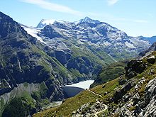
 La Ruinette from the southwest | |
| Highest point | |
| Elevation | 3,875 m (12,713 ft) |
| Prominence | 860 m (2,820 ft)[1] |
| Parent peak | Monte Rosa |
| Listing | Alpine mountains above 3000 m |
| Coordinates | 45°58′44.8″N 7°24′1.3″E / 45.979111°N 7.400361°E |
| Geography | |
| Location | Valais, Switzerland |
| Parent range | Pennine Alps |
La Ruinette is a mountain of the Swiss Pennine Alps, overlooking the Lake of Mauvoisin in the canton of Valais. With an altitude of 3,875 metres above sea level, it is the highest summit between the Grand Combin and the Dent Blanche. La Ruinette lies close to the better known Mont Blanc de Cheilon which has almost the same height (3,870 m).


See also
References
- ^ Retrieved from the Swisstopo topographic maps. The key col is the Col de Charmotane (3,015 m).
External links

See what we do next...
OR
By submitting your email or phone number, you're giving mschf permission to send you email and/or recurring marketing texts. Data rates may apply. Text stop to cancel, help for help.
Success: You're subscribed now !

