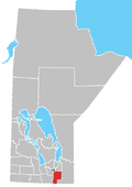
Rural Municipality of De Salaberry

De Salaberry | |
|---|---|
| Rural Municipality of De Salaberry | |
 Location of De Salaberry in Manitoba | |
| Coordinates: 49°21′11″N 97°03′47″W / 49.353°N 97.063°W | |
| Country | Canada |
| Province | Manitoba |
| Region | Eastman |
| Incorporated | December 22, 1883 |
| Named for | Charles de Salaberry |
| Area | |
| • Total | 667.57 km2 (257.75 sq mi) |
| Population | |
| • Total | 3,918 |
| • Density | 5.9/km2 (15/sq mi) |
| Area codes | Area codes 204 and 431 |
| Website | www |
De Salaberry (French: Municipalité rurale De Salaberry) is a rural municipality in the province of Manitoba in western Canada. The administratively separate village of St-Pierre-Jolys and St. Malo Provincial Park lie within the geographical borders of the municipality. The municipality is named after Charles de Salaberry.

Communities
Demographics
In the 2021 Census of Population conducted by Statistics Canada, De Salaberry had a population of 3,918 living in 1,191 of its 1,295 total private dwellings, a change of 9.4% from its 2016 population of 3,580. With a land area of 667.57 km2 (257.75 sq mi), it was sparsely populated, with a population density of 5.9/km2 (15.2/sq mi) in 2021.[1]

See also
References
- ^ a b "Population and dwelling counts: Canada, provinces and territories, and census subdivisions (municipalities), Manitoba". Statistics Canada. February 9, 2022. Retrieved February 20, 2022.
- Manitoba Historical Society - Rural Municipality of De Salaberry
- Map of De Salaberry R.M. at Statcan
External links

See what we do next...
OR
By submitting your email or phone number, you're giving mschf permission to send you email and/or recurring marketing texts. Data rates may apply. Text stop to cancel, help for help.
Success: You're subscribed now !

