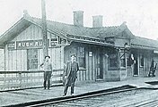
Rush Run, Ohio
Rush Run is an unincorporated community in Warren Township, Jefferson County, Ohio, United States.[1] It is mainly around the area of Rush Run Road also known as County Road 17. It is named for David Rush who settled in that area in 1798.[2]

History
An early settler in that area - James Maxwell who built a cabin near Rush Run in 1772. Maxwell was cousin to Ebenezer Zane, fled to this area to avoid prosecution for a murder. He was later proven innocent. Maxwell lived in the area for two years but returned to Virginia because of the increasing threat of American Indian uprisings. He returned to Rush Run in 1780 with his young wife, Sally.[2]

In 1910 Rush Run coal mines #1, 2 and 3 had a 5 foot #8 coal seam had a daily output of 2000 tons.[3] There is no active mining in the area at this time.

A length of nearby Ohio State Route 7 bears the name of Hall of Fame baseball player Bill Mazeroski.[4]

Education
There was once a school in the area[5] but now, public education in Rush Run is provided by the Buckeye Local School District.

Churches
There are three churches in the Rush Run area: The Rush Run United Methodist Church (no longer affiliated with the Methodist organization) is right along County Road 17. The Hopewell Methodist Church,[6] and the Rush Run Community Chapel,[7] an independent congregation.

It is home to the nearby Hopewell United Methodist Church and cemetery.[8] This site is recorded in 1785 by The American General Butler who refers to "The Sect called Methodists. In 1787 Circuit rider George Callahan preached the first Methodist sermon of record in the Northwest Territory. in 1798 the First Methodist Church in Eastern Ohio was built at Hopewell. In 1803 the first ordination in Ohio, of record, Bishop Francis Asbury ordained Rev. John Wrinshall on September 10, 1803 in Hopewell Church. In 1803 the First Methodist Meeting house in eastern Ohio was consecrated here by Bishop Francis Asbury September,11. The log church became too small by the growing congregation and was replaced in 1844 by a brick structure. The Ohio Conference cane was carved from logs from the original structure. The cane is presented to the oldest United Methodist minister in a ceremony at Annual Conference.[9]

Gallery
-
An 1856 map of the area
-
An 1871 map of the area
-
Railroad Depot - 1917
See also
References
- ^ U.S. Geological Survey Geographic Names Information System: Rush Run, Ohio
- ^ a b "Shadyside comes up short in Region 27 championship game to Newark Catholic".
- ^ Coal Mines, 1910, By B. H. Rose
- ^ "Section 5533.59 - Ohio Revised Code | Ohio Laws".
- ^ "Rush Run School".
- ^ "Google Maps".
- ^ "Churches plan special events - Steubenville, Wintersville, Toronto, Mingo, Weirton, Jefferson County | News, Sports, Jobs, HeraldStarOnline.com". Archived from the original on July 12, 2011. Retrieved November 19, 2010.
- ^ "Maps!".
- ^ "Archived copy". Archived from the original on March 20, 2006. Retrieved August 22, 2007.
{{cite web}}: CS1 maint: archived copy as title (link)
40°13′54″N 80°40′50″W / 40.23167°N 80.68056°W

See what we do next...
OR
By submitting your email or phone number, you're giving mschf permission to send you email and/or recurring marketing texts. Data rates may apply. Text stop to cancel, help for help.
Success: You're subscribed now !


