San Quintín Municipality

San Quintín Municipality
Municipio de San Quintín | |
|---|---|
| Motto: ' | |
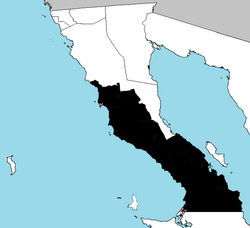
 Location of San Quintín in Baja California prior to the creation of San Felipe. | |
| Coordinates: 32°34′N 116°38′W / 32.567°N 116.633°W | |
| Country | Mexico |
| State | |
| Founded | 27 February 2020 |
| Seat | San Quintín |
| Largest city | San Quintín |
| Area | |
• Total | 32,883.93 km2 (12,696.56 sq mi) |
| Population (2020) | |
• Total | 117,568 |
| • Density | 3.6/km2 (9.3/sq mi) |
| Data source: [1] | |
| Time zone | UTC−8 (Northwest (US Pacific)) |
| • Summer (DST) | UTC−7 (Northwest) |
| INEGI code | 006 |
San Quintín is a municipality in the Mexican state of Baja California. Its municipal seat is located in the city of San Quintín, Baja California. According to the 2020 census, it had a population of 117,568 inhabitants.[2] The municipality has an area of 32,883.93 km2 (12,696.55 sq mi). There are a few National Parks and a World Heritage Site at Bahia de Los Angeles.

History
On 27 February 2020 San Quintin separated from the municipality of Ensenada, and became Baja California's sixth municipality.

Administrative divisions

| Year | Pop. | ±% |
|---|---|---|
| 2020 | 117,568 | — |
| [3][4][5][6] | ||
The municipality is divided into 8 delegations:

- Camalú
- Vicente Guerrero
- San Quintín
- El Rosario
- El Mármol
- Punta Prieta
- Bahía de los Ángeles
- Villa Jesús María.
Localities
The municipality is made up of many localities. Its urban localities in 2010 were:

- Lázaro Cárdenas (16,294)
- Vicente Guerrero (11,455)
- Camalú (8,621)
- Emiliano Zapata (5,756)
- San Quintín (4,777)
- Colonia Lomas de San Ramón (Triquis) (3,805)
- Ejido Papalote (3,413)
- Colonia Nueva Era (3,256)
- Colonia Santa Fe (2,632)

References
- ^ "México en cifras". January 2016.
- ^ "México en cifras". January 2016.
- ^ "Localidades y su población por municipio según tamaño de localidad" (PDF) (in Spanish). INEGI. Archived from the original (PDF) on 31 August 2018. Retrieved 15 July 2017.
- ^ "Número de habitantes". INEGI (National Institute of Statistics and Geography). Archived from the original on 2 July 2017. Retrieved 15 July 2017.
- ^ "Tabulados de la Encuesta Intercensal 2015" (xls) (in Spanish). INEGI. Archived from the original on 31 December 2017. Retrieved 15 July 2017.
- ^ "INEGI. Censo de Población y Vivienda 2020. Tabulados del Cuestionario Básico – Aguascalientes" [INEGI. 2020 Population and Housing Census. Basic Questionnaire Tabulations – Aguascalientes] (Excel) (in Spanish). INEGI. 2020. pp. 1–4. Archived from the original on 28 January 2021. Retrieved 27 January 2021.

See what we do next...
OR
By submitting your email or phone number, you're giving mschf permission to send you email and/or recurring marketing texts. Data rates may apply. Text stop to cancel, help for help.
Success: You're subscribed now !


