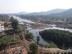
Dumka district
This article has multiple issues. Please help or discuss these issues on the talk page. (Learn how and when to remove these messages)
|
Dumka district | |
|---|---|
 Location of Dumka district in Jharkhand | |
| Country | |
| State | |
| Division | Santhal Pargana |
| Headquarters | Dumka |
| Government | |
| • Deputy Commissioner | Sri Anjaneyulu Dodde (IAS) |
| • Superintendent of police | Sri Pitamber Singh Kherwar (IPS) |
| • Lok Sabha constituencies | Dumka |
| • Vidhan Sabha constituencies | 4 |
| Area | |
| • Total | 3,716 km2 (1,435 sq mi) |
| Population (2011) | |
| • Total | 1,321,442 |
| • Density | 360/km2 (920/sq mi) |
| Demographics | |
| • Literacy | 61.02 per cent |
| • Sex ratio | 974 |
| Time zone | UTC+05:30 (IST) |
| Website | dumka |
Dumka district is one of the twenty-four districts of Jharkhand state in eastern India. Dumka is the administrative headquarters of this district. This district covers an area of 3716.02 km2. This district has a population of 1,321,442 (2011 Census).

Economy
In 2006, the Indian government named Dumka one of the country's 250 most backward districts (out of a total of 640).[1] It is one of the 21 districts in Jharkhand currently receiving funds from the Backward Regions Grant Fund Programme (BRGF).[1]

Demographics
|
| ||||||||||||||||||||||||||||||||||||||||||
| source:[2] | |||||||||||||||||||||||||||||||||||||||||||
According to the 2011 census Dumka district has a population of 1,321,442,[4] roughly equal to the nation of Mauritius[5] or the US state of New Hampshire.[6] This gives it a ranking of 370th in India (out of a total of 640).[4] The district has a population density of 300 inhabitants per square kilometre (780/sq mi).[4] Its population growth rate over the decade 2001-2011 was 19.39%.[4] Dumka has a sex ratio of 974 females for every 1000 males,[4] and a literacy rate of 61.02%. 6.82% of the population lives in urban areas. Scheduled Castes and Scheduled Tribes make up 6.02% and 43.22% of the population respectively.[4]

At the time of the 2011 Census of India, 39.71% of the population spoke Santali, 34.44% Khortha, 9.59% Bengali, 6.64% Hindi, 2.40% Malto and 1.86% Urdu as their first language. 3.02% of the population recorded their language as 'Others' under Hindi.[7]

Politics
| District | No. | Constituency | Name | Party | Alliance | Remarks | ||
|---|---|---|---|---|---|---|---|---|
| Dumka | 7 | Sikaripara | Nalin Soren | Jharkhand Mukti Morcha | Mahagathbandhan (Jharkhand) | |||
| Vacant - Won in 2024 Indian general election to Dumka Lok Sabha Constituency | ||||||||
| Dumka | 10 | Dumka | Basant Soren | Jharkhand Mukti Morcha | Mahagathbandhan (Jharkhand) | |||
| 11 | Jama | Sita Soren | Bharatiya Janata Party | NDA | ||||
| 12 | Jarmundi | Badal Patralekh | Indian National Congress | Mahagathbandhan (Jharkhand) | Cabinet Minister (Agriculture, Animal husbandry and cooperatives) | |||
Villages
See also
References
- ^ a b Ministry of Panchayati Raj (September 8, 2009). "A Note on the Backward Regions Grant Fund Programme" (PDF). National Institute of Rural Development. Archived from the original (PDF) on April 5, 2012. Retrieved September 27, 2011.
- ^ "Table A-02 Decadal Variation in Population Since 1901: Jharkhand" (PDF). census.gov.in. Registrar General and Census Commissioner of India.
- ^ "Table C-01 Population By Religion: Jharkhand". census.gov.in. Registrar General and Census Commissioner of India.
- ^ a b c d e f "District Census Handbook: Dumka" (PDF). censusindia.gov.in. Registrar General and Census Commissioner of India. 2011.
- ^ US Directorate of Intelligence. "Country Comparison:Population". Archived from the original on June 13, 2007. Retrieved 2011-10-01.
Mauritius 1,303,717 July 2011 est.
- ^ "2010 Resident Population Data". U. S. Census Bureau. Archived from the original on 2013-10-19. Retrieved 2011-09-30.
New Hampshire 1,316,470
- ^ a b "Table C-16 Population by Mother Tongue: Jharkhand". censusindia.gov.in. Registrar General and Census Commissioner of India.
External links
24°16′00″N 87°15′00″E / 24.2667°N 87.25°E

See what we do next...
OR
By submitting your email or phone number, you're giving mschf permission to send you email and/or recurring marketing texts. Data rates may apply. Text stop to cancel, help for help.
Success: You're subscribed now !


