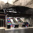
Stadshagen metro station
| Stockholm metro station | |||||||||||||||
 | |||||||||||||||
| General information | |||||||||||||||
| Location | Stadshagen, Stockholm | ||||||||||||||
| Coordinates | 59°20′14″N 18°01′04″E / 59.33722°N 18.01778°E | ||||||||||||||
| Elevation | 2.1 m (6.9 ft) above sea level | ||||||||||||||
| Owned by | Storstockholms Lokaltrafik | ||||||||||||||
| Platforms | 1 island platform | ||||||||||||||
| Tracks | 2 | ||||||||||||||
| Construction | |||||||||||||||
| Structure type | Underground | ||||||||||||||
| Accessible | Yes | ||||||||||||||
| Other information | |||||||||||||||
| Station code | SHA | ||||||||||||||
| History | |||||||||||||||
| Opened | 31 August 1975 | ||||||||||||||
| Passengers | |||||||||||||||
| 2019 | 14,050 boarding per weekday[1] | ||||||||||||||
| Services | |||||||||||||||
| |||||||||||||||
| |||||||||||||||
Stadshagen metro station is a station on the blue line of the Stockholm metro, located in the district of Stadshagen. The station was inaugurated on 31 August 1975 as part the first stretch of the Blue Line between T-Centralen and Hjulsta. The trains were running via Hallonbergen and Rinkeby.[2] The distance to Kungsträdgården is 3 km (1.9 mi).

Gallery
-
Station's artwork by Lasse Lindqvist
-
The escalators at Stadshagen Metro Station.
References
- ^ "Fakta om SL och regionen 2019" (PDF) (in Swedish). Storstockholms Lokaltrafik. p. 51. Archived (PDF) from the original on 27 December 2020. Retrieved 1 April 2021.
- ^ Schwandl, Robert. "Stockholm". urbanrail.
![]() Media related to Stadshagen Metro station at Wikimedia Commons
Media related to Stadshagen Metro station at Wikimedia Commons

See what we do next...
OR
By submitting your email or phone number, you're giving mschf permission to send you email and/or recurring marketing texts. Data rates may apply. Text stop to cancel, help for help.
Success: You're subscribed now !


