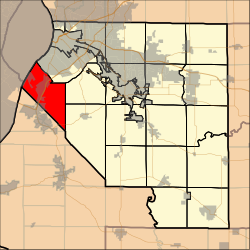
Sugarloaf Township, St. Clair County, Illinois

Sugarloaf Township | |
|---|---|
Township | |
 Location in St. Clair County | |
| Coordinates: 38°30′21″N 90°11′42″W / 38.50583°N 90.19500°W | |
| Country | |
| State | |
| County | |
| Established | November 6, 1883 |
| Area | |
• Total | 31.77 sq mi (82.3 km2) |
| • Land | 30.67 sq mi (79.4 km2) |
| • Water | 1.09 sq mi (2.8 km2) 3.43% |
| Elevation | 646 ft (197 m) |
| Population (2010) | |
• Estimate (2016)[1] | 6,891 |
| • Density | 238.7/sq mi (92.2/km2) |
| Time zone | UTC-6 (CST) |
| • Summer (DST) | UTC-5 (CDT) |
| FIPS code | 17-163-73456 |
| [2][3] | |
Sugarloaf Township is located in St. Clair County, Illinois. As of the 2010 census, its population was 7,322 and it contained 3,219 housing units.[4]

Geography
According to the 2010 census, the township has a total area of 31.77 square miles (82.3 km2), of which 30.67 square miles (79.4 km2) (or 96.54%) is land and 1.09 square miles (2.8 km2) (or 3.43%) is water.[4]

Demographics
| Census | Pop. | Note | %± |
|---|---|---|---|
| 2016 (est.) | 6,891 | [1] | |
| U.S. Decennial Census[5] | |||
References
- ^ a b "Population and Housing Unit Estimates". Retrieved June 9, 2017.
- ^ U.S. Geological Survey Geographic Names Information System: Township of Sugar Loaf
- ^ Illinois Regional Archives Depository System. "Name Index to Illinois Local Governments". Illinois State Archives. Illinois Secretary of State. Retrieved September 19, 2014.
- ^ a b "Population, Housing Units, Area, and Density: 2010 - County -- County Subdivision and Place -- 2010 Census Summary File 1". United States Census. Archived from the original on February 12, 2020. Retrieved May 28, 2013.
- ^ "Census of Population and Housing". Census.gov. Retrieved June 4, 2016.
External links

See what we do next...
OR
By submitting your email or phone number, you're giving mschf permission to send you email and/or recurring marketing texts. Data rates may apply. Text stop to cancel, help for help.
Success: You're subscribed now !

