Hasties Swamp National Park

| Hasties Swamp National Park Queensland | |
|---|---|
 | |
| Nearest town or city | Atherton, Queensland |
| Coordinates | 17°18′01″S 145°28′27″E / 17.30028°S 145.47417°E |
| Established | 5 April 1980 |
| Area | 57 ha (140.9 acres) |
| Visitation | (in 2012) |
| Managing authorities | Queensland Parks and Wildlife Service |
| Website | Hasties Swamp National Park |
| See also | Protected areas of Queensland |
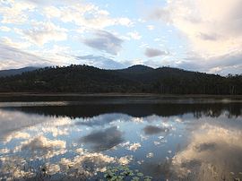
Hasties Swamp is a national park in Queensland, Australia, 1,371 km northwest of Brisbane. The swamp is located several kilometres south of the town of Atherton in Far North Queensland.[1] The main feature of the park is a seasonal wetland. Part of the swamp was first declared a national park on 5 April 1980.[2]

Habitat protected within the park supports up to 300 species of birds.[2] These include the sarus crane, pale-vented bush-hen and buff-banded rail.[1]

A bird hide provides viewing opportunities for visitors, including those using wheelchairs.[3]

The wetland is surrounded by open eucalypt forest.[4] The average elevation of the terrain is 826 metres.[5]

See also
References
- ^ a b Thomas, Richard; Sarah Thomas; David Andrew; Alan McBride (2011). The Complete Guide to Finding the Birds of Australia. Csiro Publishing. p. 96. ISBN 0643102264. Retrieved 5 January 2013.
- ^ a b Nature, culture and history Archived 9 December 2014 at the Wayback Machine. Department of National Parks, Recreation, Sport and Racing. 27 April 2012. Retrieved on 5 January 2012.
- ^ "Hasties Swamp National Park". Queensland Holidays. Tourism and Events Queensland. Retrieved 5 January 2013.
- ^ "About | Hasties Swamp National Park". Parks and forests | Department of Environment and Science, Queensland. 14 May 2007. Retrieved 1 June 2022.
- ^ "Hasties Swamp National Park topographic map, elevation, relief". topographic-map.com. Retrieved 1 June 2022.
External links

See what we do next...
OR
By submitting your email or phone number, you're giving mschf permission to send you email and/or recurring marketing texts. Data rates may apply. Text stop to cancel, help for help.
Success: You're subscribed now !

