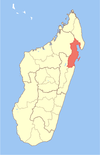
Mananara Avaratra (district)
(Redirected from Mananara Avaratra District)
Mananara Avaratra (district)
Mananara Nord (district) | |
|---|---|
 | |
| Coordinates: 16°10′S 49°46′E / 16.167°S 49.767°E | |
| Country | |
| Region | Analanjirofo |
| Area | |
• Total | 4,487 km2 (1,732 sq mi) |
| Elevation | 12 m (39 ft) |
| Population (2020)[2] | |
• Total | 261,784 |
| • Density | 58/km2 (150/sq mi) |
| Time zone | UTC3 (EAT) |
| code | 511 |
Mananara Avaratra is a district of Analanjirofo in Madagascar.[3][4] The district has an area of 4,487 km2 (1,732 sq mi), and the estimated population in 2020 was 261,784.[5]

Communes
The district is further divided into 16 communes:

- Ambatoharanana
- Ambodiampana
- Ambodivoanio
- Analanampotsy
- Andasibe
- Antanambaobe
- Antanambe
- Antanananivo
- Imorona
- Mahanoro
- Manambolosy
- Mananara Nord
- Sandrakatsy
- Saromaona
- Tanibe
- Vanono
References
- ^ Estimated based on DEM data from Shuttle Radar Topography Mission
- ^ TROISIEME RECENSEMENT GENERAL DE LA POPULATION ET DE L’HABITATION
- ^ REPOBLIKAN'I MADAGASIKARA:Tanindrazana – Fahafahana – Fandrosoana (PDF). MINISTERE DE L’AGRICULTURE, DE L’ELEVAGE ET DE LA PECHE. October 2007. pp. 42–44.
- ^ "Madagascar: Administrative Division". citypopulation. Retrieved 10 June 2018.
- ^ "Mananara Avaratra (District, Madagascar) - Population Statistics, Charts, Map and Location". www.citypopulation.de. Retrieved 2024-01-17.
See what we do next...
OR
By submitting your email or phone number, you're giving mschf permission to send you email and/or recurring marketing texts. Data rates may apply. Text stop to cancel, help for help.
Success: You're subscribed now !


