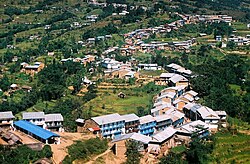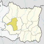
Diktel Rupakot Majhuwagadhi Municipality
Diktel Rupakot Majhuwagadhi Nagarpalika
दिक्तेल रूपाकोट मझुवागढी | |
|---|---|
| Diktel Rupakot Majhuwagadhi Municipality | |
 Diktel Rupakot Majhuwagadhi Nagarpalika (Diktel Bazar, Khotang) | |
| Coordinates: 27°12′50″N 86°47′52″E / 27.21389°N 86.79778°E | |
| Country | |
| Province | Province No. 1 |
| District | Khotang District |
| Government | |
| • Mayor | Tirtharaj Bhattrai ( (NC)) |
| • Deputy Mayor | Bishan Rai (Maiost) |
| Area | |
| • Total | 246.51 km2 (95.18 sq mi) |
| • Rank | 8th (Province No. 1) |
| Highest elevation | 2,250 m (7,380 ft) |
| Lowest elevation | 700 m (2,300 ft) |
| Population (2011) | |
| • Total | 46,903 |
| • Density | 190/km2 (490/sq mi) |
| [1] | |
| Time zone | UTC+5:45 (NST) |
| Website | official website |

Diktel Rupakot Majhuwagadhi is a Municipality in Khotang District of Province No. 1 of Nepal. The municipality was established in May 2014 merging some the previous Village Development Committees (VDCs) of Bamrang, Laphyang and Kahalle as Diktel Municipality.[1][2]

Diktel was renamed to Rupakot Majhuwagadhi on 10 March 2017 after merging some more VDCs. The municipality is divided into 15 wards. It is on 700 m to 2250 m of elevation from sea level. The area of the municipality is 246.51 km2. There are 10,050 households with population of 46,903.[3][4] By 2020, the name commonly used name Diktel was re-added to the municipality's official name.[citation needed]

Transportation
Man Maya Airport lies in Old-Diktel offering flights to Kathmandu.[5]

Media
To promote local culture, Diktel has two community radio stations: Halesi FM (102.4 MHz) and Rupakot Radio (105.0 MHz).

Climate
| Climate data for Diktek (Dwarpa), elevation 1,829 m (6,001 ft), (1961–1990) | |||||||||||||
|---|---|---|---|---|---|---|---|---|---|---|---|---|---|
| Month | Jan | Feb | Mar | Apr | May | Jun | Jul | Aug | Sep | Oct | Nov | Dec | Year |
| Mean daily maximum °C (°F) | 13.8 (56.8) |
15.6 (60.1) |
20.2 (68.4) |
22.6 (72.7) |
23.2 (73.8) |
23.8 (74.8) |
23.6 (74.5) |
23.6 (74.5) |
22.7 (72.9) |
21.7 (71.1) |
18.7 (65.7) |
15.5 (59.9) |
20.4 (68.8) |
| Daily mean °C (°F) | 7.5 (45.5) |
9.1 (48.4) |
13.3 (55.9) |
16.6 (61.9) |
18.1 (64.6) |
19.7 (67.5) |
20.0 (68.0) |
19.7 (67.5) |
18.7 (65.7) |
16.7 (62.1) |
12.3 (54.1) |
8.8 (47.8) |
15.0 (59.1) |
| Mean daily minimum °C (°F) | 1.3 (34.3) |
2.9 (37.2) |
6.4 (43.5) |
10.6 (51.1) |
13.1 (55.6) |
15.6 (60.1) |
16.3 (61.3) |
15.8 (60.4) |
14.8 (58.6) |
11.6 (52.9) |
5.9 (42.6) |
2.2 (36.0) |
9.7 (49.5) |
| Average precipitation mm (inches) | 11.0 (0.43) |
6.0 (0.24) |
47.0 (1.85) |
60.0 (2.36) |
144.0 (5.67) |
309.0 (12.17) |
365.0 (14.37) |
330.0 (12.99) |
213.0 (8.39) |
103.0 (4.06) |
9.0 (0.35) |
5.0 (0.20) |
1,602 (63.08) |
| Source: FAO[6] | |||||||||||||
References
- ^ 72 new municipalities announced Archived June 18, 2014, at the Wayback Machine My Republica
- ^ Govt announces 72 new municipalities Archived 2014-10-06 at the Wayback Machine The Kathmandu Post
- ^ "Introduction". rupakotmajhuwagadhimun.gov.np. Mofald.gov.np. 8 October 2017. Retrieved 23 February 2018.
- ^ "Rupakot Majhuwagadhi Municipality in Nepal Population". www.citypopulation.de. Retrieved 23 February 2018.
- ^ "KHANIDANDA (MANAMAYA RAI) AIRPORT" (PDF). CAAN. Retrieved 5 January 2020.
- ^ "World-wide Agroclimatic Data of FAO (FAOCLIM)". Food and Agriculture Organization of United Nations. Retrieved 23 June 2024.
External links

See what we do next...
OR
By submitting your email or phone number, you're giving mschf permission to send you email and/or recurring marketing texts. Data rates may apply. Text stop to cancel, help for help.
Success: You're subscribed now !


